CityDashBoard TalesofThings MapTube
Qrator Tutorials About Digital Urban
MRes ASAV SurveyMapper Contact Us
Showing posts sorted by relevance for query 3d tube. Sort by date Show all posts

2009-03-10

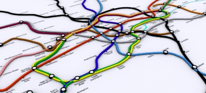
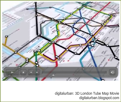
3D London Tube Map Movie

*Update - see 3D Tube Map Update for the latest movie - Update*


London Tube Map Geography:Visualisation Draft from digitalurban on Vimeo.


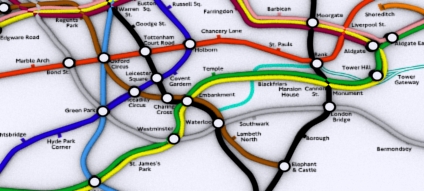
The movie above is a draft look at our 3D London Tube Map with the lines laid out according to their geographic location. The movie was made as a test to explore mental ray settings in 3ds Max, total render time was 36 hours.

Below is the actual tube map, again visualised via 3ds Max:


London Tube Map Traditional Layout from digitalurban on Vimeo.


For those interested see our 3D Tube Map thread for more images.

2008-03-18

London 3D Tube Map in Google Maps


Sometimes when jumping from project to project and tutorial to tutorial projects get lost and posts overlooked.

One such example is our 3D Tube Map which, despite being something we are quite proud off, sat on the shelf for a while due to lack of time. Embedded below is the project so far - click and drag to pan around and zoom in and out using the usual google map interface (created using our free Image Cutter Software):


UCL is currently working on a render farm of 250 or so processors for our London model, so fingers crossed the 3D Tube project will be back in movie form soon.

For those with eagle eyes we know of at least two 'errors' in the map :) We will get these fixed and if anyone wants the image as wallpaper let us know your resolution and we'll post up an image.

View the map full screen

Update -Digital Geography - Geographic Visualisation for Urban Environments, the booklet of the blog is now available to buy.

2007-07-30

Iconic London - 3D Tube Map Update


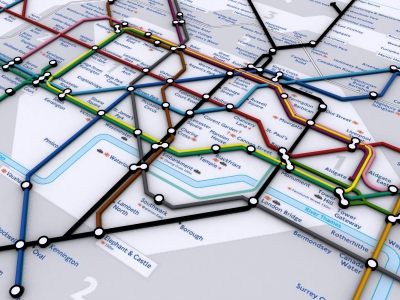
A quick update on our Iconic London 3D Tube Map - we are going through the process of vectorising the base data which basically involves re-entering all the tube station names in 3D Max. Its turning into a slight labour of love which seemed like a good idea when we first thought about it, the image below details progress so far in the central section.

Click and drag to pan or the +/- icons to zoom in and out:


The final London wide version should be ready shortly...

2007-07-18

Tutorial - The 3D London Tube Map from Adobe Acrobat to 3DMax


Rapid visualisation of networks can be carried out by simply converting Adobe Acrobat documents to .dwg format as we detail below with a quick render of the London Tube map:

Modelling of the tube lines was possible using the following workflow:

1) Download a Acrobat formatted 2D map from the London Transport site;

2) Import into Adobe Illustrator;

3) Export as .DWG which preserves the vector line data;

4) Import into 3DMax and converting the line data into 3D Splines.

This provides a quick and easy way to transform a 2D map into 3D. A movie illustrating work in progress is embedded below:


The same technique can be used for the actual geographical location of the London Tube Network:


These are sample images of a file recently retrieved from a lost disk - we will be updating the 3D Map over the coming weeks.

2007-09-05

Digital Urban - The Tutorials

This post contains links to all of our tutorials to date - created as a reference page for blog links or bookmarks to ensure the tutorials can be easily found.

The post will be updated whenever a new tutorial is added.

We hope you like them, if there is any tutorial you like to see just let us know..

Photoshop Image Stacking for Day Trails


Reactor Basics: 3D Max, Bouncing Balls in a 3D City

3D Max Balls in the City from digitalurban on Vimeo.


Torch + Webcam = HD Timelapse System


Image Stacking for Star Trails and City Air Activity at Night


iPhone Timelapse Tutorial


Greeble a 3D City: Tutorial 1: Greeble Skyscraper


Greeble a 3D City: Tutorial 2: The Cityscape


Google Earth PhotoOverlay - Download and Tutorial


How to Capture Google Maps for Printing and Poster Design


How to Create Engaging Movies from Google Earth & Virtual Earth


How To Create Aerial Panoramas from Virtual Earth


How to Create an Aerial Panorama from Google Earth


How to use Google Earth as a Panorama Viewer -Tutorial and Files


How to Create Engaging Movies from Google Earth & Virtual Earth


How to Create Quick and Easy Augmented Reality from SketchUp/3DMax etc


How to create Panoramas from Oblivion


How to Import SketchUp/3D Max into the Oblivion Engine for Architectural Visualisation - Part 1

How to Import SketchUp/3D Max into the Oblivion Engine for Architectural Visualisation Part 2


How to Stitch a Panorama with the Nokia N95


How to Geotag Photographs on the Nokia N95 for Google My Maps and Flickr


How to create Isometric Pixel Art - Simulating in SketchUp Tutorial


How to Create The 3D London Tube Map from Adobe Acrobat to 3DMax

2005-12-21

3D London Tube Map Update


A quick update on the real 3D tube map of London. Data on the depth of the tube stations is proving tricky to get hold of due to security issues. One simple way would be to count the number of steps down to each station - so if anyone on their way to work could count the steps down and email them in that would be great!


The map can then be updated as and when the number of steps are sent in..

2010-07-13

Digital Urban: Top Five Favourites

Summer seems to be a good time of year to dig out those movies that we have liked over our time on digital urban so far. First off we are going to look at our own movies (its slightly indulgent) that in the 1500 odd posts often get lost, we will run through why they were made, the software involved and their place in the bigger picture.

Full post with movies after the break below:

2009-02-25

Back to the Tube: 3D London Underground in Google Maps

We are revisiting this earlier work due to a meeting today with regards creating visualisations of the London Underground. The work started out with the movie below of the traditional tube map. Created direct from a .pdf file via London Transports website it provided a 'quick and dirty' flythrough of the map:


London Tube Map Traditional Layout from digitalurban on Vimeo.


We then looked at creating a geographical version with the aim to morph in 3D between the two.


Pictured below is the layout so far using Google Maps 'without the map'. Aimed at creating a 'plasticine' look to the routes the interactive image below illustrates a work in progress produced so we can easily identify the errors. Double click to zoom in and drag to pan:


There are a few errors here and there but it should only need a few tweaks to be near a complete version which can then be morphed and changed as needs be.

You can also view the 'Google Maps' version full screen (recommended).

Thanks go to Simon Clarke who produced the original geographic tube map. Simon's site is currently under reconstruction in the meantime take a look at other London Underground diagrams.

2009-07-31

Microsoft Seadragon: Point to an Image and Process - 3D Tube Map

Microsoft have revamped their http://www.seadragon.com/ service and its quite impressive in terms of sharing high resolution images online.

Below is our 10000x5000 pixel render of the 3D London Tube Map - it enables you to zoom in enough to see the parts we need to fix :)


If you have Silverlight installed it should zoom in nice and smoothly, if not it should use Ajax so we would be interested in any thoughts on its performance.

Set up is as easy as pointing the service at a online image, it then processes it and makes it as simple as adding in a one line script to a blog post / web page. We are not sure however know where it stores the images so if its a photograph you don't want sitting on a Microsoft server somewhere you might want to use other alternatives - such as our Image Cutter :)

2006-07-05

3D London Tube Map


A while ago we built a map of the London Tube network.. its neat but to be honest not all that much use (?). Somewhere on our hardrive is a real location of the map in 3D as well, we will hopefully dig that back out in a few days. You can view the current 'classic' London Tube Map below:


The reason for the post? We were going to add in depth data to produce a real representation of the tube network. Sadly due to security fears (which are understandable to say the least) this looks like it wont happen. Still, it would of made a neat flythough...

A higher res version can be found can be viewed from here (23Mb). Note the movie uses the DIVX codec.

2009-04-29

Unity Game Engine for Architectural Visualisation: A First Look

This is our first look at Unity - an integrated authoring tool for creating 3D video games or other interactive content such as architectural visualizations or real-time 3D animations. The editor runs on Windows and Mac OS X and can produce games for Windows, Mac, Wii, or iPhone platforms. It can also produce browser games that use the Unity web player plugin, supported on Mac and Windows.

We have spent the morning dragging and dropping files into the interface for direct viewing in the game engine. In short, we are impressed at the shear ease of use, within 15 minutes we had our both our 3D Tube Map and Greeble City complete with sky box, lighting and first person viewpoint up and running:


For anyone used to having to jump through various hoops to get models into a game engine Unity is quite simply a breath of fresh air. There are two main licenses: Unity Indie ($199), and Unity Pro ($1499). Unity Pro is required for businesses with over $100,000 turnover/year.

Our movie was produced via the 30 day trial of the Indie version, we will be taking a closer look at Unity over the coming weeks, for now see http://unity3d.com/unity/ for more information.

2007-07-19

3D London Underground Image


Readers maybe aware of our on-going work to build a 3D map of the London Tube network. Depth information is hard to come by due to issues of security therefore the work has concentrated on creating a 3D geographic location map.

Aimed at creating a 'plasticine' look to the routes the interactive image below illustrates a work in progress produced so we can easily identify the errors. Double click to zoom in and drag to pan:


The final cleaned up version will be online shortly.

You can also view the image full screen (recommended).

Thanks go to Simon Clarke who produced the original geographic tube map. Simon's site is currently under reconstruction in the meantime take a look at other London Underground diagrams.

2005-11-10

3D London Tube - Streaming a Movie via Flash


The majority of our movies have been encoded in Divx which although useful for compression does mean that people need the correct codec installed. As a test we have put online a movie encoded into Flash so the majority of users will be able to view it. The filesize is also compact, down from 23Mb to 2.2Mb which should be streamed from our server.

The movie itself features a fly through of the iconic tube map of London.

Any comments would be welcome...

View the movie encoded in Flash. (2.2mb).

2007-09-18

Working Paper - Public Domain GIS, Mapping & Imaging Using Web-based Services

We have a new working paper out entitled: Public Domain GIS, Mapping & Imaging Using Web-based Services by Andrew Hudson-Smith, Richard Milton, Michael Batty, Maurizio Gibin, Paul Longley, Alex Singleton.

The paper outlines Google Map Creator, Image Cutter, Google Earth Creator, Map Tube and our recent work in Second Life.

In the last five years, public domain GIS (geographic information systems) software for map display and beyond has become available for non-expert users in the public domain, the best examples being the various products from Google such as Google Maps and Google Earth.

We have devised various software to enable non-experts to take appropriate map data in standard formats and to transform them so that they can be displayed by these software in a one stop action.

The first system is called GMapCreator and we show how the software can be used to produce any number of map layers which can be overlaid on Google Maps, can be combined and toggled in combination, and whose transparency can be varied for a myriad of presentation purposes.

We then evolve this into a form called ImageCutter which takes any large image and puts this into a Google Map so that the zoom and pan features of the software can be exploited. These software are now available through a site we call MapTube which is a server pointing to various maps created by GMapCreator which is a rudimentary archive of virtual map resources.

Finally, we sketch how these software are being moved into 3D using the capabilities of Google Earth and Second Life to display geographic imagery.

You can download the working paper in .pdf format (3301KB)