Sometimes when jumping from project to project and tutorial to tutorial projects get lost and posts overlooked.
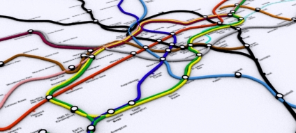
One such example is our 3D Tube Map which, despite being something we are quite proud off, sat on the shelf for a while due to lack of time. Embedded below is the project so far - click and drag to pan around and zoom in and out using the usual google map interface (created using our free Image Cutter Software):
UCL is currently working on a render farm of 250 or so processors for our London model, so fingers crossed the 3D Tube project will be back in movie form soon.
For those with eagle eyes we know of at least two 'errors' in the map :) We will get these fixed and if anyone wants the image as wallpaper let us know your resolution and we'll post up an image.
View the map full screen
Update -Digital Geography - Geographic Visualisation for Urban Environments, the booklet of the blog is now available to buy.

It would be really great to see this in Google Earth, and probably not that difficult if you already have the 3D models.
ReplyDeleteok, so are the two errors the lack of the jubilee line and the fact that the east london line goes into liverpool street?
ReplyDeletesorry to be picky, but comments like 'for the eagle eyed' are red rag to a bull
lol yep thats two - and there is another one i know off...
ReplyDeleteall these will be fixed btw :)
arrgh! how am I supposed to get any work done now!
ReplyDeleteWhat happened to Highbury & Islington?!
ReplyDeleteI just noticed that when you click on an underground station symbol in Google Maps, an overlay appears of all the lines that pass through that station. I'm not sure whether this is a new feature, but its a welcome one.
ReplyDeleteCan't seem to find a way to install this type of thing into my program...
ReplyDeleteBut it looks great with the models and everything...