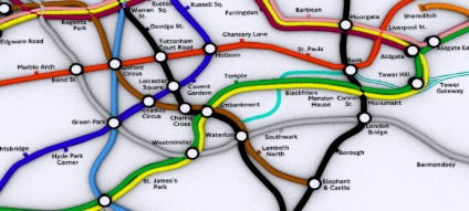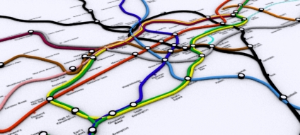
A quick update on the real 3D tube map of London. Data on the depth of the tube stations is proving tricky to get hold of due to security issues. One simple way would be to count the number of steps down to each station - so if anyone on their way to work could count the steps down and email them in that would be great!

The map can then be updated as and when the number of steps are sent in..

This stuff is amazing!
ReplyDeleteQueensway (which is currently closed) is 123 steps down (I've run it up quite a few times, rather than wait for the lifts!). I've not looked at the map, but I've always been interested how the tube actually is underground.
ReplyDeleteDoes anyone have a list of the lat/lon coordinates of each Tube station, both above and below ground? I'd like to create an animation showing the amount of spatial deformation necessary to take all the stations from their real location to where they are positioned in the London Underground map.
ReplyDeletecan i just add that the ground level at each station isn't the same (wrt sea level), so counting the number of steps won't give the most accurate result for your model.
ReplyDeleteI like what you're doing here, is there a higher res version of this i can get hold of?
DL made a good point. Not all of the stations are the same level so counting the steps will not work, unless you can relate them to a starting height.
ReplyDeleteGoogle Earth provides you with the lat, long and elevation for the surface entrances for the stations though, so you could use that. For example, BlackFriars exit 8 is at 51'30'40.00N, 0'06'15.83E and is 14m above sea level.
Given the inaccuracy of hand held GPS units in terms of elevation, and also the time it would take someone to survey each of these in, I don't believe these would be practical.
I love what you are trying to do. I'll start counting next time I am on the tube...
Regards
Chris Reardon
Yes, this is brilliant. I'm trying to time a journey which can be achieved in various different ways. Total nerd!
ReplyDeleteChanging trains can be such a pain and takes so long. By the time you've got off a train, walked along a platform, up the escalator, along a corridor, down another escalator, along another corridor, down another escalator, along the platform and on the train I'm beginning to think it would have been quicker to have walked. We need more information before starting a journey. Which is deepest in central London: Bakerloo, Northern, Metropolitan, Piccadilly or Jubilee?
:(
Hampstead is 300 steps (deepest station)
ReplyDeleteChalk Farm is 57 steps
more to follow
some interesting figures here too, about depth in relation to sea level etc
ReplyDeletehttp://www.faqs.org/faqs/uk/transport-london/section-7.html
Take a barometric altimeter with you.
ReplyDelete