
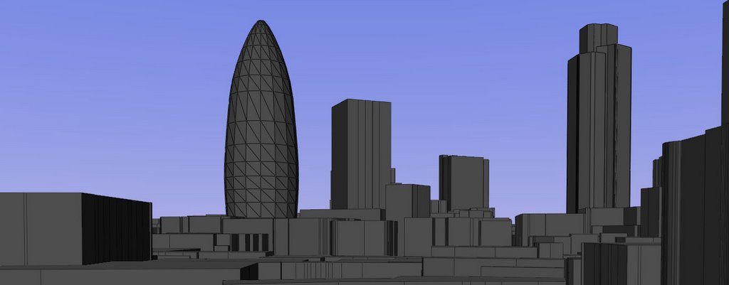
Its been a day of hitting our head against the wall - which is sometimes good as not everything is meant to be easy. Importing into Half Life is however proving to be more difficult than first thought. We have managed to import into The Unreal Engine complete with textures to create a 3D section of London but Half Life 2 has left us stumped.
Apparently its easy to go from Hammer (the Half Life editor) to CAD via DXF but not visa versa. We are going to plough on and still hope to home into a clear route from packages such as SketchUp to Half Life but it may take a few more days...
- Any help on this btw would be most welcome -
2006-08-31
2006-08-30
Importing CAD into Half Life 2
We are just working out a clear and easy route to import CAD to the Half Life 2 Source Engine. At the moment progress is slow and mainly trial and error. However, once we crack it we should have a tutorial in place to get from SketchUp to HalfLife.
Fingers crossed.. at the moment its proving to be painful..
Andy
Fingers crossed.. at the moment its proving to be painful..
Andy
2006-08-29
Worlds within Worlds for Architectural Visualisation

The second in our series exploring high definition (1280x720) panoramas expands the concept to explore 'worlds within worlds'. Embedding panoramas in a x/y/z space allows movies to be created where the camera automatically pans around a scene. Panoramas are traditionally interactive, thus all our output via this blog is available in Quicktime Virtual Reality. However, if you are going to display panoramas in a stand alone location, such as the front of an office or marketing suite, a movie is more suitable and thus the requirement to move panoramas into a 3D package.
If you expand this concept and embed panoramas within panoramas you can create 'worlds within worlds', as illustrated in the movie above. This allows a series of panoramas to be embedded within a 'holding' scene and presents a looping movie suitable for large displays.
The YouTube movie is for rapid visualisation only, the High Definition version can be downloaded here (94Mb High Definition wmv format).
2006-08-24
Frank Lloyd Wright Architectual Visualisation in Half Life
In a follow up to our previous post on City 17, the fictional location for Half Life, we now take a first look at using the game engine for Architectural Visualisation. A Half Life user known as Kasperg has produced a model of the Kaufmann House by Frank Lloyd Wright in the Half Life Source Engine.
Using the Source Engine, as opposed to more traditional Architectural Software, allows the use of dynamic lighting and a real-time walkthrough of the scene in high resolution. The movie demonstrates the quality of Half Life for visualisation using both a standard walkthrough and half way through a fly-through using the Half Life 'Noclip' option.
*Update - see our Game Engines thread for visualising Architecture in Oblivion*
A higher resolution version of the movie can be download from here (wmv 57Mb).
Technorati Tags:frank lloyd wright, architect, architecture, half life, game engine, mod, 3d flythrough
Generated By Technorati Tag Generator
Cities in Games - City 17 - Half Life 2
Continuing our series of Cities in Games we take a first look at City 17, the location of Half Life 2. Half-Life 2 is a science fiction first-person shooter game which, running in the Source Engine developed by Valve Corporation, allows a number of advanced rendering effects. Our movie below is a first look at the environments and rending of City 17 during the first part of the game.
As we have mentioned before the use of games in the work environment is often frowned upon, yet games allow the use of technology that traditional CAD render packages often fail to match. Of note in the movie is the level of immersion of the environment through the use of real-time lighting techniques and texturing.
We will be posting more movies of the Architecture of Half Life 2 shortly as well as progress and a explanation of how to modify the game engine for urban planning and architecture participation.
A higher resolution version of the movie can be downloaded here (wmv, 33Mb)
2006-08-23
Project Gotham Racing 3 XBox 360 Cities Video
The best architectural renderings of cities are not to be found in research labs or in virtual reality theatres but on game consoles and of these Project Gotham 3 Racing (PGR3) on the Xbox 360 stands out from the crowd. Developed from the original Metropolis Street Racer on the Dreamcast (see our Cities in Games posts for details) PGR3 takes architectural rendering to new levels.
The movie below concentrates on views of the cities, notable is the London Eye towards the end of the clip.
Once we rig up our XBox 360 to a capture card we will feature more movies of the cities featured as well as a post on the making of PGR3.
The movie below concentrates on views of the cities, notable is the London Eye towards the end of the clip.
Once we rig up our XBox 360 to a capture card we will feature more movies of the cities featured as well as a post on the making of PGR3.
2006-08-22
Google Earth London Placemark Movie (SoundTrack Test)
The movie was created whilst examining the models performance with various placemarks, in this case the London Tube stations of Bank, Barbican, Euston, Waterloo and Kings Cross.
The model streams in nicely although some slow down is evident in places. We might be out of the park on this one but we added a Trance soundtrack as it was all a bit dull without audio.
Not sure if it works but still, its just an experiment in soundtracks to Google Earth, if anyone else knows of a Google Earth movie with a good soundtrack (apart from from Jason Dancing..which if you havent seen it is neat, although not as good as the genius that is Where the Hell is Matt) let us know..
A higher resolution version can be downloaded here (.wmv 46Mb)
2006-08-21
London Google Earth - Splicing in Landmarks and Network Streaming
 Our post on progress in the London Google Earth Model last week highlighted the ability to stream in data using the Network capability of KML thanks to Richard Milton at CASA.
The movie displayed was created using data direct from Ordnance Survey Master Map. This is suitable for general outlines but not for landmark buildings that require higher levels of detail. To import these into Google Earth we have used a combination of ESRI's ArcGIS, SketchUp, GeoTools and good old Notepad. The landmark KMZ's are spliced into the original file structure allowing Network Streaming functionality with the inclusion of landmark buildings. The latest movie illustrates the Swiss Re and Tower 42 in the wider context of the London model.
All the work flows are in place all we need now is for the parties involved to sort out their data licensing policy...
2006-08-19
Movie Updates and Up and Coming
A new cloud time lapse movie is online, movies are now grouped under the Cloud Time Lapse Link in the right hand side naviagtion bar.
We have left a new High Defintition panorama movie rendering in the lab over the weekend. The movie take 60 hours to render so fingers crossed we will post it early next week.
Finally, the template is still playing up in IE6 with the links to the right sometimes jumping to the bottom of the page. Everything works in Firefox though and as soon as Blogger Beta allows Raw HTML editing we should have it fixed.
2006-08-18
London Clouds 17th August 2006
We are not sure about these posts to be honest... but for those interested (and there doesn't seem to be many of you!) here is the latest 12 hour time lapse movie of clouds over the City of London.
We have a new link on the right hand side of Cloud Time Lapse this will be the location for future posts...
We have a new link on the right hand side of Cloud Time Lapse this will be the location for future posts...
2006-08-17
Blog Upgrades
The blog is moving over to a beta version of blogger.. the old template is no longer operational so give us a few hours and we should have everything back in place..
*Update *
The beta version of blogger does not yet allow editing of the raw html so our template size cannot be changed. This is resulting in the side bar dropping off to the bottom of the page in IE6 but all is fine in Firefox.
As soon as html editing is included in Blogger we will get the site back up to scratch.. till then all the links are now structured so the site is easy to use and navigate.. if you can find the side bar!
Google Earth London - Level of Detail/Network Links
Loading large city models requires intelligent data management and loading structures, especially in the case of Virtual London where the model now extends to over 2000 Km in extent. To manage the data, Richard Milton here at CASA has written a KML file to use the Network Link function of KML and Level of Detail to intelligently load in Google Earth files depending on the users' viewpoint. The movie below demonstrates this tile loading ability:
All of London's 33 Boroughs are included in the file structure allowing a seamless flythough of the 3D data. Due to ongoing licensing issues this will only currently be available on computer systems run internally within the Boroughs - but it provides an insight into how the work is progressing...
*Update - see also post on Splicing Landmark Buildings and Network Streaming -
A higher resolution version of the movie can be downloaded here (39Mb WMV)
Google Earth Paper Models
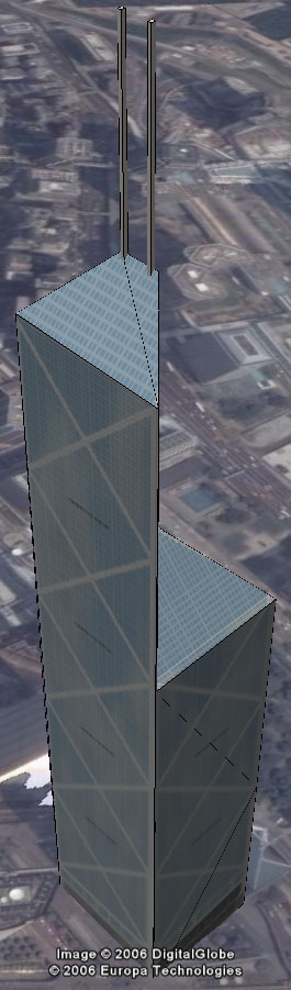 Google Earth is about data, to construct 3D models of cities you need data on heights and textures. In our post on Canary Wharf we point to how the model was constructed using Emporis as a reference. Another route however is to look at paper models and Skyscrapermodels.us by John Townsend is an excellent resource. The site provides full plans of a number of notable skyscrapers which are designed to be printed out onto card or paper and folded to construct the geometry.
Pictured above are the plans designed by John for the Bank of China in Hong Kong. Our cutting and glueing skills are quite frankly limited but by placing the texture in SketchUp you can cut and fold digitally. Combine this with the ability of Google Earth Beta 4 to import textures and you can quickly create a 3D model which can be exported and viewed in context.
Our model of the Bank of China was made by simply tracing the outline in Google SketchUp for each section and rotating (folding) along the lines as indicated in the drawing. We would be interested in any other models made this way as there are a numerous paper model folding sites on the web.
You can download the model of the Bank of China here (168K)
Other posts of interest are:
Tutorial on creating 360 x180 degree panoramas in Google Earth
2006-08-16
London MonoMetro 2012 Visualising the City
Just out on YouTube is a link to MonoMetro a proposal for a new rapid transit system in London. The info on MonoMetro makes its clear that its not a Mono Rail system but a narrow gauge mono-path railway...
To be honest we cant see it working but the movie displays a good use of a real world video and digital overlays to visualise the proposed impact of the MonoMetro system. It also illustrates how much of a visual impact the system would have on London and for that reason alone its probably a non-starter..
To be honest we cant see it working but the movie displays a good use of a real world video and digital overlays to visualise the proposed impact of the MonoMetro system. It also illustrates how much of a visual impact the system would have on London and for that reason alone its probably a non-starter..
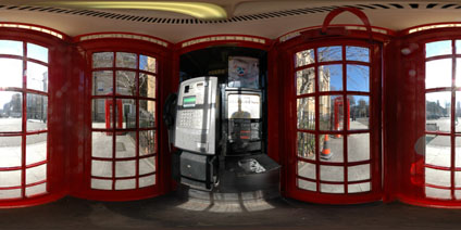
The 'K6' Jubilee London Telephone Box Panorama
Revisiting a post featuring a panorama inside a Red Telephone Box we now have a outside view of the location in Byng Place.
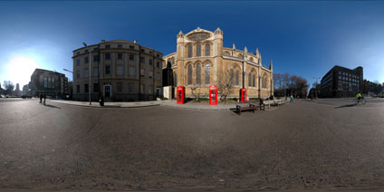
Registered as Grade II listed buildings the phoneboxes are set against the backdrop of the Church of Christ the King in Bloomsbury.
The Red Phonebox is a classic design by Sir Giles Gilbert Scott who amoungest other notable buildings also designed Battersea Power Station. The K6 "Jubilee" model pictured here was built to commemorate the Silver Jubilee of King George V in 1935.
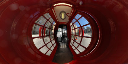
View the Quicktime panorama of Inside the Red Phonebox in London (3.2mb).
View the Quicktime panorama of Outside the Phonebox and the Church of Christ the King in Bloomsbury (2.7mb).
Registered as Grade II listed buildings the phoneboxes are set against the backdrop of the Church of Christ the King in Bloomsbury.
The Red Phonebox is a classic design by Sir Giles Gilbert Scott who amoungest other notable buildings also designed Battersea Power Station. The K6 "Jubilee" model pictured here was built to commemorate the Silver Jubilee of King George V in 1935.
View the Quicktime panorama of Inside the Red Phonebox in London (3.2mb).
View the Quicktime panorama of Outside the Phonebox and the Church of Christ the King in Bloomsbury (2.7mb).
London Clouds 15th August 2006
While this section beds in we will post the occasional updates on the main page to highlight the London Cloud Time Lapse Movies. In general the daily movies are now grouped in a single post so bookmark this page if your interested.
London Cloud Time Lapse for 15/08/2006
Next week the movies will hopefully be time stamped along with general weather data presented as a overlay. If this works then we should be able to provide automatic updates on the page every 10 minutes and every hour. Daily movies will still be posted every morning around 11am London time.
2006-08-15
London Clouds Daily Time Lapse
To cut down on the large number of posts the daily time lapse movies would create we are going to group them all in this section (so bookmark this section if your interested). The updates are still experimental but fingers crossed in the next week or so we will have automatic updates for every ten minutes cloud time lapse movies and a regular post of daily movies.
Latest Movie:
London Cloud Time Lapse for 18/08/2006
A good day for passing showers in the movie, a gust of wind moves the camera at one point.
London Cloud Time Lapse for 17/08/2006
London Cloud Time Lapse for 16/08/2006
Due to a hardware error the movie only covers the evening period. Apologies - this is now fixed and tomorrow's movie should be back to normal. Its a nice sunset though..
London Cloud Time Lapse for 15/08/2006
London Cloud Time Lapse for 14/08/2006
As ever, thoughts or comments(?)
Chicago Skyline Panorama Millennium Park
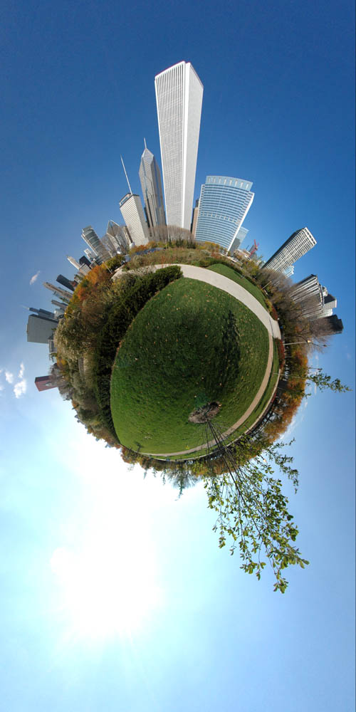
Another in the Chicago series of panoramas, this time further out in Millennium Park. Millennium Park is located in the heart of downtown Chicago. It is bordered by Michigan Avenue to the west, Columbus Drive to the east, Randolph Street to the North and Monroe Street to the South.
The panorama was taken on our way down to capture the Yacht Club Panorama, one of a number of views we captured of Chicago. The others in the series can be found by simply typing Chicago into our search box on the top right.
You can click the image to get a larger view or..View the quicktime virtual reality panorama of Millennium Park, Chicago (3.4Mb).
2006-08-14
Cloud Gate Chicago Panorama

London is far too overcast today for panoramas so we thought we would post a shot we took on a conference trip to Chicago late last year of Cloud Gate in Millenium Park.
Cloud Gate is British artist Anish Kapoor's first public outdoor work installed in the United States. The 110-ton elliptical sculpture is forged of a seamless series of highly polished stainless steel plates, which reflect the city's famous skyline and the clouds above. A 12-foot-high arch provides a "gate" to the concave chamber beneath the sculpture, inviting visitors to touch its mirror-like surface and see their image reflected back from a variety of perspectives.

Inspired by liquid mercury, the sculpture is among the largest of its kind in the world, measuring 66-feet long by 33-feet high. Larger versions of the images can be viewed by clicking on them, or you can..
View the quicktime virtual reality panorama of The Cloud Gate Sculpture, Chicago (2.2Mb).
London Clouds Time Lapse Movie
Clouds over cities are interesting - no really they are - when viewed over a period of time it gives a new dimension to the skyline. We have finally got our Time Lapse Camera working and this is the first test in hopefully a regular series of London's Cloudscape Time Lapse movies. If we find our ladder the movies will feature the whole of London skyline, at the moment it covers the area from Centre Point and the BT Tower towards Victoria.
The flashing light at the bottom left hand corner is the BT Tower...
A higher resolution (640x480) version of the movie can be found here - London's Clouds Time Lapse (1)(54Mb).
Any thoughts of comments as ever are welcome.
The flashing light at the bottom left hand corner is the BT Tower...
A higher resolution (640x480) version of the movie can be found here - London's Clouds Time Lapse (1)(54Mb).
Any thoughts of comments as ever are welcome.
2006-08-11
Second Life - The Metaverse Gets Noticed
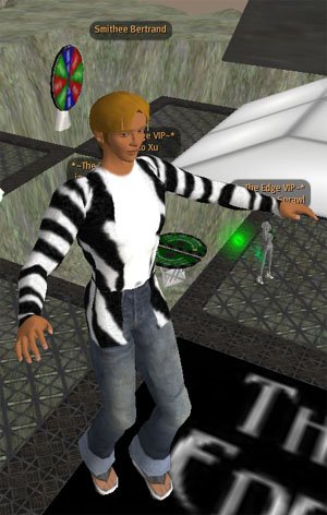 Second Life is beginning to enter the main stream. First the BBC's Radio One set up home in the Virtual World and now Duran Duran are set to perform 'live'. We are posting this as a reader requested a high resolution copy of the movie that accompanies our original Second Life Post.
Sadly that now only exists on YouTube due to a mix up with our Recycle Bin. YouTube is fine for the web but not much use for a conference presentation.
So we have remade the movie and a Pal resolution version can be downloaded from here (11Mb)..
With all the recent media interest the Metaverse is suddenly getting noticed. Back in the days when ActiveWorlds was the next big thing and we ran the 30 Days in ActiveWorlds experiment we bet our bottom dollar that Virtual Worlds were about to become main stream. They didn't of course and a number of companies went bankrupt. Second Life it seems is giving the Virtual World a second chance.
2006-08-10
Virtual London - Rebuilt Within the M25
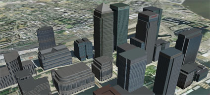
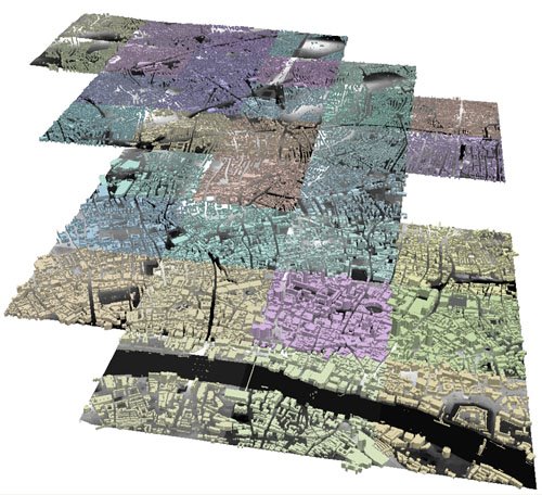 The Virtual London model at CASA is currently being rebuilt from the bottom up with a new dataset. The new model will include all of the London buildings within the M25 and will be available to London Boroughs within the next few weeks under a cost free license negotiated through London Connects. The image to the right illustrates the first early stages with City, Camden and Islington in place. It is now going out to a few select test Boroughs to make sure it runs 'in house'. Linking this with SketchUp and Google Earth (behind the Boroughs internal firewalls until License issues are overcome) will present planners and architects with a unique tool in which to visualise and plan London. It is also being imported into ArcExplorer to examine the possibilities of Spatial Analysis.
Further updates and screenshots will follow over the coming weeks....
Londonist...
 For those wanting to know a little more about Digital Urban, Londonist has run a interview providing some background on the research around Virtual London and how Digital Urban came about. They are also planning to run a competition to win a high resolution 18 x24 inch print of one of our 'Urban Bubble' panoramas shortly so keep watching the site. This will be a first edition print so well worth looking out for (in our humble opinion of course!)....
2006-08-09
Metropolis Street Racer - Cities in Games - London ,Tokyo and San Francisco
 Continuing in our series of Cities in Games we cast our eye back to Metropolis Street Racer (MSR) on the Dreamcast Console by SEGA in 2001. MSR holds the accolade of being the first game to make us sit back in wonder, not at the gameplay but at the rendition of the cities of London, Tokyo and San Francisco.
The use of games in both architecture and planning is limited, yet back in 2001 Bizzare Creations, the creators behind MSR, had a better model of three of the worlds cities than most, if not all, of the architecture companies at that time. Games should not be seen as something more aligned to teenagers and kept tucked away in bedrooms, the latest, and indeed consoles from the past, should be given pride of place in the the office as a reminder of how advanced city visualisation currently is and how many companies are still struggling to reach 2001 console levels of rendering.
The development of MSR was, at the time, impressive - allowing players to drive around areas of London including St James Park, Trafalgar Square and Westminster taking in all the sights of Buckingham Palace, Admiralty Arch and Leicester Square to name but a few. In a city plagued by congestion to scream around city and end with a handbreak turn outside Buckingham Palace couldn't fail to make you smile. Which is why perhaps games are so frowned upon in the


workplace...

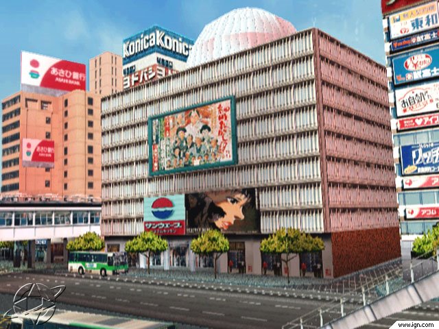
Technically however, MSR now seems very simple. Each city was constructed from block extrusions and texture mapped with a simplified texture taken from a photograph. The screenshot above of Tokyo was compared favorably in a interview on IGN as being almost indistinguishable from the real location. In reality of course the building is a textured box, but in 2001 this was state of the art. Coming forward to 2006 this is where we are today with SketchUp modelling and Google Earth. Version 4 beta of Google Earth allows texture rendering and by linking with SketchUp you can create rapid city models with phototexturing, in a similar manner to MSR.
The use of textures to provide the sense of location is clearly demonstrated in the video of MSR below:
MSR was a first - a series of cities created from textures that finally allowed the user to identify with locations, it was the first game to truly replicate the real world and give the user a sense of location and space. Sadly the Dreamcast was Segas' swansong and marked their exit from the hardware market.
MSR was re-rendered and rejuvenated on the XBox under the title Project Gotham Racing 1 and 2 and more recently version 3 on the XBOX 360. These versions will be the subject of a future post on Cities in Games as they moved on from creating cities using simple phototextures to increasingly complex geometry.
2006-08-08
Goggles - A Google Map Flight Sim
 Goggles is a Flight Simulator using images loaded in from Google Maps. Running in Flash it is a technical achievement to overlay the plane (which is controlled via the arrow keys) onto the air photographs - a concept which opens up any array of possible applications. There are currently five cities to choose from when you load up the game - London, Paris, New York, Tokyo and Washington.
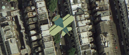 Googles is a simple concept which has been very well executed, note that you can use the space bar to fire but you have to be near the ground which in our case led to frequent crashing. The game, developed by Mark Caswell-Daniels is currently in beta. Mark is actively looking for other funded projects so anyone out there with some funding should drop Mark a email and develop a Google Maps version of Time Pilot!
2006-08-07
Banksy Roundhouse Camden - London Panorama
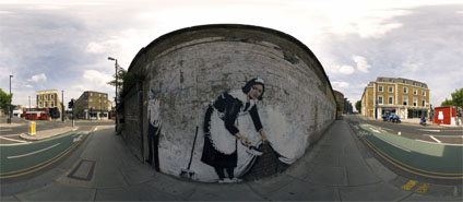
The panorama is captured in front of the Chambermaid stencil by the artist Banksy, created in May 2006, on the wall of the Roundhouse in Camden. According to the Camden New Journal Article the maid is a portrait of Leita who worked in a Hotel in Los Angeles.
Libbey Cambell the newly elected Liberal Democrat Councilor stated that "Banksy should of got permission for the art and ask who is going to pay to have it removed?". We are glad to say that is hasn't been removed as the owners of the Roundhouse rather like it and it is refreshing to see innovative images on the streets of London. As for Libbey, you would of thought she would have other things to worry about in Camden to be honest...
View the Quicktime panorama of Banksy's Stencil at the Roundhouse, Camden, London (2.9Mb). You can also simply view a larger version of the image (290K).
For those who want to learn more about Banksy's Street Art the movie below from the Culture Show provides a good insight:
More Banksy Street Panoramas will hopefully follow..
The Tube - London Panorama
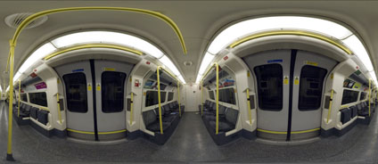
The average speed of a Tube train in London is 33 km per hour (20.5mph) - including station stops. This makes capturing a panorama on the Tube tricky due to the movement of the train. Luckily these average figures don't really tell the full story and the Tube is often subject to delays and periods of unexplained stoppages in tunnels.
Thus during a particular long delay between Mornington crescent and Camden Town we were able to fully assemble our panoramic rig and capture the resulting panorama.
View the panorama of The Tube, London (2.9Mb).
Sketch Drawing Primrose Hill London

Sometimes panoramas just dont work, despite carrying your kit on a hot summers day to the top of one of London's best views the output is just not quite right. So the panorama that was going to be featured here of Primrose Hill failed, however due to the lighting conditions it did lend itself to a few Photoshop filters aimed at creating a sketch view of the skyline.
Obtaining sketches of the London skyline is not easy yet, in our view at least, they would make a highly desirable framed print on our office wall. Which is why we are providing the full size version of the Sketch of Primrose Hill London at 2894 x 701 pixels for download.
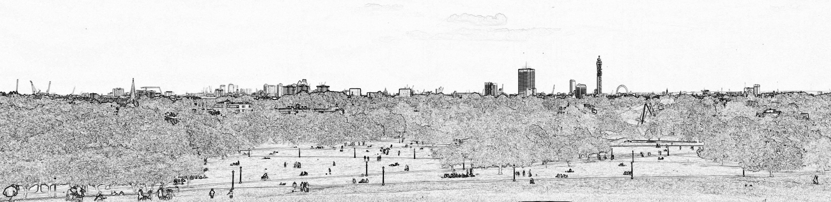
If you like it let us know... come to think of it let us know if you dont like it as well..
2006-08-04
Gangs of London - Cities in Games - London on a PSP
Fresh after we posted on The Getaway - London - Cities in Games we view a post on Londonist that the forthcoming Playstation Portable Game 'Gangs of London' has been released into the wild via bitorrent before the code is complete.
Of interest to us is the intro movie below which shows how London is rendered on the Playstation Portable.
We recommend you wait for the official release but in terms of visualising cities it clearly demonstrates what can be done on hand held consoles.
Of interest to us is the intro movie below which shows how London is rendered on the Playstation Portable.
We recommend you wait for the official release but in terms of visualising cities it clearly demonstrates what can be done on hand held consoles.
2006-08-03
Google Earth Controlled via Atlas Gloves - Video Demo
Further to our previous post on Controlling Google  Earth ala Minority Report, thanks to the Atlas Gloves from was Dan Phiffer and Mushon Zer-Aviv, we decided to try them out for ourselves.
Using a pair of ping pong balls, that Joel our System Administrator found in a cupboard at home, a couple of led torches from down Tottenham Court Road and a touch of superglue we cobbled together our interpretation of the Atlas Glove controllers. (pictured right).
For our test we utilized a projector displaying Google Earth and the control software in a blacked out lecture theatre. This allowed a clear view of the lights which are turned on and off in combination with various hand gestures to remotely control Google Earth. The movie below demonstrates the trial, we were going to leave the movie audio free but couldn't resist dubbing in the The Sorcerer's Apprentice by Stokowski. The controller is Joel who quickly became a master of the technique.
Linking Google Earth to a remote vision based control interface is impressive and the fact it worked first time is testament to the teams clear instructions and software.
Of note to some users experiencing a 'Grey Screen' when loading the software, through trial and error we found that you also need to install WinVDIG version 1.1.1 (not the current 1.5 release). This enabled the control software to communicate with the webcam.
 Earth ala Minority Report, thanks to the Atlas Gloves from was Dan Phiffer and Mushon Zer-Aviv, we decided to try them out for ourselves.
Using a pair of ping pong balls, that Joel our System Administrator found in a cupboard at home, a couple of led torches from down Tottenham Court Road and a touch of superglue we cobbled together our interpretation of the Atlas Glove controllers. (pictured right).
For our test we utilized a projector displaying Google Earth and the control software in a blacked out lecture theatre. This allowed a clear view of the lights which are turned on and off in combination with various hand gestures to remotely control Google Earth. The movie below demonstrates the trial, we were going to leave the movie audio free but couldn't resist dubbing in the The Sorcerer's Apprentice by Stokowski. The controller is Joel who quickly became a master of the technique.
Linking Google Earth to a remote vision based control interface is impressive and the fact it worked first time is testament to the teams clear instructions and software.
Of note to some users experiencing a 'Grey Screen' when loading the software, through trial and error we found that you also need to install WinVDIG version 1.1.1 (not the current 1.5 release). This enabled the control software to communicate with the webcam.
2006-08-02
Microsoft Photosynth linked with Virtual Earth? - Automatic Generation of Digital Cities?
 Google Earth changed the way we see and distribute information, it made Geography important and for those working in the field of Geographical Analysis allowed them to quickly and easily share information. What it didn't do was make the creation of content any easier, either in the second or thrid dimensions.
The third dimension is the tricky one, building Virtual Cities takes time and money, autogenerated 3D cities are some years away and if you combine this with the need for photorealism and the ability and zoom into minute details then you are talking a huge undertaking.
So what is needed is a new line of thought - A new process which takes normal everyday photographs which are cheap and easy to capture and mosaic them together into a 3D mesh so the camera is always looking directly from the angle the photograph was taken from. If you can pan between these angles and add as many photographs as you wish you can create a photographic mesh of a city. This is what Photosynth from Microsoft does and it has the sort of impact of when you first saw Google Earth - its a stand back moment and then you realise the implications.
 The Photosynth Website features a video which talks you through the concept and shows some examples. Full details are sketchy at the moment but its looking like we could walk around a section of London taking images from as many angles as possible and then automatically create a virtual tour around it in 3D. Sure its not a full photogrammetric model but if it portrays a sense of location and space, linked to other media, then in some ways it is more valuable than a heavy polygon count model.
The final thought is linked to the fact that the demonstation video makes a passing mention of working with the team developing Virtual Earth. If this system is incorporated in Microsoft Virtual Earth then we have the possibility to link the ground photographs with oblique imagery via Microsoft Live and then create a full photorealistic 3D mesh from the view of Earth to the closest detail you can capture at macro level.....
2006-08-01
Minority Report Interface to Google Earth


Picked up via the ever impressive Oogle Earth Blog is the news that Atlas Gloves was Dan Phiffer and Mushon Zer-Aviv part of the ITP - NYU’s Interactive Telecommunication Program. have developed a pair of 'Atlas Gloves'. The gloves are a DIY physical interface for controlling 3D mapping applications like Google Earth. The user interface is based around a pair of illuminating gloves that can be used to track intuitive hand gestures like grabbing, pulling, reaching and rotating. The Atlas Glove website has a video of the interface in action as well as details on how to build you own from a pair of ping pong balls, led lights and a webcam.
We are on the case and people are being dispatched to locate ping pong balls as we type. If we get it up and running we will put up a post as well as contacting the team to see if we can help out in any way with other applications such as ArcExplorer (?)....
****
As an update we have our ping pong balls (thanks Joel), super glue and a couple of cheap led torches. If we dont glue our fingers together we should be running a test this afternoon and updates will follow on our progress. (2nd August 2006).
****
Google Earth Canary Wharf
Last Friday we posted a movie created of Canary Wharf from simply downloading the models at the Google 3D Warehouse. The models were created by
Olivier Salome (with the tag Jef at the 3D Warehouse) and we asked him to get in touch.. thankfully he did and he agreed to a short interview into how he built the model and his future plans. He also allowed us to post his latest Google Earth file of Canary Wharf which can be found at the end of the interview and is well worth a download. If you havent seen the movie already you can view it by clicking play below:
1) I notice you are based in Brussels, what got you interested in modelling London?
I am amazed to see the huge building effort London is taking to transform its skyline. In the City of London, 30St Mary Axe (Norman Foster, 180m) is one of the most ingenious and elegant new skyscraper built anywhere in the world. It will soon be joined by other stunning structures such as e.g. 122 Leadenhall Street (Richard Rogers, 224m) and the Shard London Bridge (Renzo Piano, 306m). In the Docklands, Canary Wharf has become one of the most vibrant and fast growing new business district in Europe and its tallest tower at One Canada Square (235m, Cesar Pelli) is also a remarkable piece of architecture. Then I came to know the excellent modelling work undertaken at CASA/UCL and in particular the 3D London models shared on the blog. I was so impressed at the results that I decided to try myself some simple modelling exercises.
2) Distance modeling is never easy, how to you get your data.. more especially the outlines of buildings, the heights and the textures?
Emporis is one of the world's largest publicly available database on architectural and building data. Plans related to planning applications are published on the websites of the Corporation of London and Tower Hamlets. Architects, developers and letting agents also release some of the information I need to undertake 3D modelling. I would also like to mention the London forum thread on skyscrapercity where quality pictures are regularly posted as well as relevant architectural information and links.
3) Can you give us an idea of your work flow?
It takes time to collect all the information before I can actually start modelling with Google Sketchup. Buildings at Canary Wharf are not difficult to model - compared to e.g. 30St Mary Axe. However, it is difficult to ensure consistency in terms of colours, especially for those buildings in stainless steel and glass. Overall it took me about a month to make that model.
4) What buildings can we look forward to in the future?
Canary Wharf has started its new phase of mid-rise developments around Churchill Place on the eastern edge of the cluser. The two "Pan Peninsula" residential towers at the adjacent Millennium Quarter are also under construction. These will be added to the model. I have also started modelling New Providence Wharf opposite the Millennium Dome and Ontario Tower which is due for completion later this year. Meanwhile I am working on some buildings in the City of London.
In some ways it is amazing how quickly 3D modelling of cities has essentially become Open Source thanks to Google Earth and modellers like Jef. You can download his latest version of Canary Wharf from here (6Mb) and we thank Olivier for his time and look forward to some more more buildings in Olivier's section of the Google 3D Warehouse.
Olivier Salome (with the tag Jef at the 3D Warehouse) and we asked him to get in touch.. thankfully he did and he agreed to a short interview into how he built the model and his future plans. He also allowed us to post his latest Google Earth file of Canary Wharf which can be found at the end of the interview and is well worth a download. If you havent seen the movie already you can view it by clicking play below:
1) I notice you are based in Brussels, what got you interested in modelling London?
I am amazed to see the huge building effort London is taking to transform its skyline. In the City of London, 30St Mary Axe (Norman Foster, 180m) is one of the most ingenious and elegant new skyscraper built anywhere in the world. It will soon be joined by other stunning structures such as e.g. 122 Leadenhall Street (Richard Rogers, 224m) and the Shard London Bridge (Renzo Piano, 306m). In the Docklands, Canary Wharf has become one of the most vibrant and fast growing new business district in Europe and its tallest tower at One Canada Square (235m, Cesar Pelli) is also a remarkable piece of architecture. Then I came to know the excellent modelling work undertaken at CASA/UCL and in particular the 3D London models shared on the blog. I was so impressed at the results that I decided to try myself some simple modelling exercises.
2) Distance modeling is never easy, how to you get your data.. more especially the outlines of buildings, the heights and the textures?
Emporis is one of the world's largest publicly available database on architectural and building data. Plans related to planning applications are
 published on the websites of the Corporation of London and Tower Hamlets. Architects, developers and letting agents also release some of the information I need to undertake 3D modelling. I would also like to mention the London forum thread on skyscrapercity where quality pictures are regularly posted as well as relevant architectural information and links.
3) Can you give us an idea of your work flow?
It takes time to collect all the information before I can actually start modelling with Google Sketchup. Buildings at Canary Wharf are not difficult to model - compared to e.g. 30St Mary Axe. However, it is difficult to ensure consistency in terms of colours, especially for those buildings in stainless steel and glass. Overall it took me about a month to make that model.
4) What buildings can we look forward to in the future?
Canary Wharf has started its new phase of mid-rise developments around Churchill Place on the eastern edge of the cluser. The two "Pan Peninsula" residential towers at the adjacent Millennium Quarter are also under construction. These will be added to the model. I have also started modelling New Providence Wharf opposite the Millennium Dome and Ontario Tower which is due for completion later this year. Meanwhile I am working on some buildings in the City of London.
In some ways it is amazing how quickly 3D modelling of cities has essentially become Open Source thanks to Google Earth and modellers like Jef. You can download his latest version of Canary Wharf from here (6Mb) and we thank Olivier for his time and look forward to some more more buildings in Olivier's section of the Google 3D Warehouse.
Subscribe to:
Comments (Atom)