 Google Earth changed the way we see and distribute information, it made Geography important and for those working in the field of Geographical Analysis allowed them to quickly and easily share information. What it didn't do was make the creation of content any easier, either in the second or thrid dimensions.
The third dimension is the tricky one, building Virtual Cities takes time and money, autogenerated 3D cities are some years away and if you combine this with the need for photorealism and the ability and zoom into minute details then you are talking a huge undertaking.
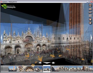
So what is needed is a new line of thought - A new process which takes normal everyday photographs which are cheap and easy to capture and mosaic them together into a 3D mesh so the camera is always looking directly from the angle the photograph was taken from. If you can pan between these angles and add as many photographs as you wish you can create a photographic mesh of a city. This is what Photosynth from Microsoft does and it has the sort of impact of when you first saw Google Earth - its a stand back moment and then you realise the implications.
 The Photosynth Website features a video which talks you through the concept and shows some examples. Full details are sketchy at the moment but its looking like we could walk around a section of London taking images from as many angles as possible and then automatically create a virtual tour around it in 3D. Sure its not a full photogrammetric model but if it portrays a sense of location and space, linked to other media, then in some ways it is more valuable than a heavy polygon count model.
The final thought is linked to the fact that the demonstation video makes a passing mention of working with the team developing Virtual Earth. If this system is incorporated in Microsoft Virtual Earth then we have the possibility to link the ground photographs with oblique imagery via Microsoft Live and then create a full photorealistic 3D mesh from the view of Earth to the closest detail you can capture at macro level.....

I agree with you Andy that this Photosynth stuff is very cool. My hope is that Google won't be far behind, or possibly ahead, in integrating this kind of technoloy with Picasa and Google Earth. Already there are signs they are integrating with the recent Picasa 2 Beta supporting georeferencing of photos with Google Earth. See this story.
ReplyDeleteHi
ReplyDeleteThought you would like to know the VE team have already progresses with this.
They currently have a test of street side views:
http://preview.local.live.com/
They are working on integrating this into virtual earth like the birds eye views are currently.
Aparently they will have some major us cities and london (city of) done this year!
There biggest problem is they have to remove all the identifyable people and car plates!!!!!
Brian Norman
www.earthware.co.uk
What if:
ReplyDeleteMicrosoft joined their efforts with Google and combined PhotoSynth with Panoramio? This would really make an astonishing application.
I think the combination of the two technologies would mean the start of a whole new era in which people will start to experience the world in a whole new manner:
Public user content of the world available through Panoramio can be used to recreate it in a digital-online setting. This would mean a way to automatically digitizing all wonders of the world (being buildings, panorama) in full picture glory. It also means other users are given the change to experience such a location in three dimensions without ever going there.
Geez, i really hope to visit some more wonders of the world this way... Ofcourse after being there in person 8-)
What's you're opinion?
Greetings,
Peter Vrenken