CityDashBoard TalesofThings MapTube
Qrator Tutorials About Digital Urban
MRes ASAV SurveyMapper Contact Us
Showing posts with label Photosynth. Show all posts

2009-10-08

Photosynth - New Overhead View and the du Carpark

We have been doing some photosynth work recently on an automatic workflow for 600+ image captures and upload - so far its working well and we will put up a post shortly, in the meantime photosynth now includes a new over head view, as the video below illustrates:

Photosynth Overhead View from Microsoft Photosynth on Vimeo.


Photosynth never got as much coverage here on du as it deserved, its only the last few weeks with the ability to mass record images and extract a mesh out of the system that it has grabbed out attention. For those who cant wait you can see the unflattering 'du carpark' over on the main photosynth site. The main point to note is that is was automated and made in under 5 minutes.

We hope to capture something a little more interesting for the main post on the subject...

2009-09-23

Photosynth Point Export - Photosynth as a 3D Scanner?

Take a look at the movie below and make sure you watch it all the way through - note the export of the model from photosynth into a stand alone 3D package:


This opens up the possibility of using photosynth as a free 3D scanner, and one that would work on objects up to the building level scale. It seems to be early days but there is a lot of discussion going on around the tutorial here.

If anyone has any more insight do let us know via the comments...

2009-05-16

Photosynth Now Integrated with Virtual Earth

We have been big fans of the Photosynth technology here at digital urban, it has huge potential for portraying the cityscape from the level of external architecture through to inside buildings and down to individual objects.

Microsoft have just launched Photosynths integration with Virtual Earth along with some tweaks to the interface, the slightly corporate and stumbled through video below provides details:


While it is still early days the example of the House Synth over at http://www.microsoft.com/virtualearth/ details the possibilities, now if they would just let us open the the resultant point cloud in application such as 3D Max....

2009-01-21

Obama Photosynth Video: The Moment CNN


Microsofts Photosynth is without question a technology to watch and CNN have pushed it to a new level with their capture of the moment Barack Obama placed his hand on the bible and took the presidential oath of office.

Our movie below takes a quick tour around the resulting Photosynth:


Obama CNN The Moment Photosynth: The Inauguration from digitalurban on Vimeo.


You can view the Photosynth direct - Windows and Mac compatible - via the CNN page.

Its a really interesting visual capture of a moment in time using the crowd as a source of data.

2009-01-18

CNN Plans Obama Inauguration 3D Capture: Photosynth and Crowd Sourcing


Post update - video of the resulting Photosynth is now part of a new post here.

Microsofts Photosynth is without question a technology to watch and CNN are about to push it to a new level with their plans to capture a moment in time in 3D. The moment of capture is January 20th 12:00pm ET when Barack Obama places his hand on the bible and takes the presidential oath of office.

At that point if you are in the crowd CNN wants you to:
1. Take one photo of the moment when Obama takes the oath. If you have a digital camera with a zoom lens, take three photos (wide-angle, mid-zoom, full-zoom)

2. E-mail each photo as soon as possible to themoment@cnn.com (one photo per message, 10MB size limit). Don't forget to include your name in the message if you'd like to appear in the list of the contributors. Please only send in photos you took yourself.

3. Go to cnn.com/themoment to see all of the photos in our photosynth
Its an intriguing idea to capture a moment in time in 3D using essentially crowd sourced images, we cant wait to see how it turns out.

Take a look at CNNs 'The Moment' site for more information.

2008-10-08

The Making of Photosynth: Points, Lines and Polygons - Digital Architecture


The Making of Photosynth from Nathanael Lawrence on Vimeo.


The video above looks at the making of Photosynth, its informative and provides a glimpse of where Photosynth is going.

In truth we are simply at the beginning of being able to take crowd sourced or self taken imagery and automatically construct scenes, it is without question however an exciting beginning.

We have a feeling that in a few years time we will be explaining to our students that to create a 3D building we used to actually manually draw in the polygons, line by line, window by window and door by door.

We are close to it all becoming automatic and while we may miss the 'hand made approach' and indeed the argument is about to start that there will always be a role of 'hand made' digital architecture, we think its only a few years off becoming automated.

In the same way that Google Earth/Google Maps changed the field of GIS, the technologies behind Photosynth maybe about to change the world of architectural visualisation.

See also Can Photosynth Change The World Of Architecture? (we think it can btw...)

2008-10-02

Finding Paths through the World's Photos: A Crowd Sourced Photosynth


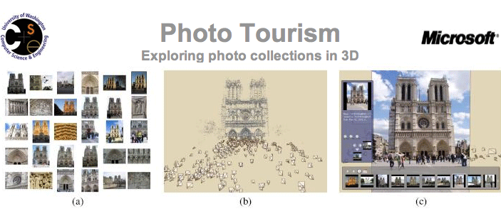
Noah Snavely, Rahul Garg, Steven M. Seitz of the University of Washington and Richard Szeliski of Microsoft Research have published a paper well worth reading entitled Finding Paths through the World's Photos in ACM Transactions on Graphics (SIGGRAPH 2008) [download the pdf]

The movie embedded below above details their talk at SIGGRAPH and provides a much more intriguing look at 3d construction from crowd sourced photos than the current Photosynth release:


In overview the concept is:

When a scene is photographed many times by different people, the viewpoints often cluster along certain paths. These paths are largely specific to the scene being photographed, and traverse interesting regions and viewpoints. We seek to discover a range of such paths and turn them into controls for image-based rendering. Our approach takes as input a large set of community or personal photos, reconstructs camera viewpoints, and automatically computes orbits, panoramas, canonical views, and optimal paths between views. The scene can then be interactively browsed in 3D using these controls or with five degree-of-freedom free-viewpoint control. As the user browses the scene, nearby views are continuously selected and transformed, using control-adaptive reprojection techniques.


Take a look at the Photo Tourism Page for more info.

2008-10-01

Photosynth for Urban Visualisation

We haven't had much chance recently to put Photosynth through its paces - but one natural application is for the visualisation of architecture. Hidenori Watanave and students from Tokyo Metropolitan University have used it in such a way to create a 'synth' of the Nakagin Capsule Tower" by Japanese architect Kisho Kurokawa:


We are still undecided on photosynth, at the moment it seems like an impressive tech demo, if they offered the ability to download the point cloud it would make it a much more interesting application...

See http://archidemo.blogspot.com/ for more of Hidenori's work.

2007-06-07

Photosynth - London Trafalgar Square

Photosynth is one of those applications that has the potential to change the way we view images and 3d models of our environment. By automatically linking images together in a spacial context each photograph becomes part of a three dimensional model. This not only allows ease of navigation and a better understanding of the geographic context of each image but also allows the rapid construction of three dimensional space.

Microsoft have just released another preview of Photosytnh, this time featuring Trafalgar Square in London. The YouTube movie below details our first navigation around the scene:


To gain a further insight into Photosynth it is worth taking 5 mintues to sit back and watch a presentation below by Blaise Aguera y Arcas:


Of note is the integration with Flickr and other photosharing sites - essentially allowing a global image base to be integrated within Photosynth. If you combine this with imagery via Microsoft's Virtual Earth - notably BirdsEye - then you begin to approach a new way to visualise image data in 3D space..

Try out the Tech Preview of Photosynth.

2006-08-02

Microsoft Photosynth linked with Virtual Earth? - Automatic Generation of Digital Cities?

Google Earth changed the way we see and distribute information, it made Geography important and for those working in the field of Geographical Analysis allowed them to quickly and easily share information. What it didn't do was make the creation of content any easier, either in the second or thrid dimensions.

The third dimension is the tricky one, building Virtual Cities takes time and money, autogenerated 3D cities are some years away and if you combine this with the need for photorealism and the ability and zoom into minute details then you are talking a huge undertaking.

So what is needed is a new line of thought - A new process which takes normal everyday photographs which are cheap and easy to capture and mosaic them together into a 3D mesh so the camera is always looking directly from the angle the photograph was taken from. If you can pan between these angles and add as many photographs as you wish you can create a photographic mesh of a city. This is what Photosynth from Microsoft does and it has the sort of impact of when you first saw Google Earth - its a stand back moment and then you realise the implications.
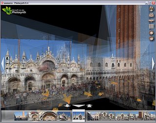
The Photosynth Website features a video which talks you through the concept and shows some examples. Full details are sketchy at the moment but its looking like we could walk around a section of London taking images from as many angles as possible and then automatically create a virtual tour around it in 3D. Sure its not a full photogrammetric model but if it portrays a sense of location and space, linked to other media, then in some ways it is more valuable than a heavy polygon count model.

The final thought is linked to the fact that the demonstation video makes a passing mention of working with the team developing Virtual Earth. If this system is incorporated in Microsoft Virtual Earth then we have the possibility to link the ground photographs with oblique imagery via Microsoft Live and then create a full photorealistic 3D mesh from the view of Earth to the closest detail you can capture at macro level.....