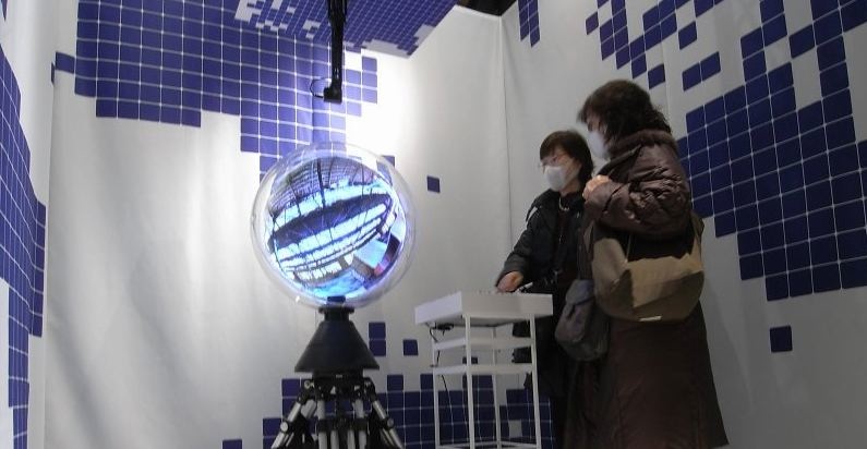
The movie below details a spherical display under the name of Panorama Ball Vision:
The display seems suitable for use with Google Earth or any panoramic based imagery, we don't think the masks in the picture are due to any harmful output from the actual device...
We have been big fans of the Photosynth technology here at digital urban, it has huge potential for portraying the cityscape from the level of external architecture through to inside buildings and down to individual objects.
Microsoft have just launched Photosynths integration with Virtual Earth along with some tweaks to the interface, the slightly corporate and stumbled through video below provides details:
While it is still early days the example of the House Synth over at http://www.microsoft.com/virtualearth/ details the possibilities, now if they would just let us open the the resultant point cloud in application such as 3D Max....
We knew this was coming and indeed it was possible via other routes but its still quite a notable move with ESRI teaming up with Microsoft to offer Virtual Earth directly within ArcGIS. The full announcement is below:
ESRI Expands Virtual Earth Access in GIS by Teaming with Microsoft
ArcGIS Users to Bring Dynamic Basemaps into Analysis and Service Applications
Redlands, California—March 26, 2009— ESRI announced today anew agreement with Microsoft Corporation that gives ArcGIS users fast access to Microsoft Virtual Earth for their geographic information system (GIS) projects. As part of ArcGIS Online at the ArcGIS 9.3.1 release, ArcGIS Desktop and ArcGIS Server users will be able to connect directly to Virtual Earth and quickly start their GIS projects with ready-to-use content.
"Our agreement with Microsoft defines a pattern of sharing geospatial data on the Web that promises to grow the GIS community," says ESRI President Jack Dangermond. "By bringing Virtual Earth into their GIS projects, people will have a greater opportunity to perform spatial analysis based on dynamic data."
ArcGIS users who are current on maintenance and have an Internet connection will have access to Virtual Earth for a variety of up-to-date mapping content.including aerial imagery, roads, and hybrid (aerial with labels) imagery. With a familiar look, imagery access will appear as another data layer in GIS. The imagery will provide excellent background maps on which users can overlay their operational data. This means users will be able to focus more on their business data than on its context.
For example, an electric utility can layer its distribution line data over a Virtual Earth aerial view of a neighborhood to create a map of its lines and customer connections. This Virtual Earth background layer is useful for editing the company's data and can be easily shared online with other company users.
ArcGIS users can build Web applications that support geospatial services through ArcGIS Server and ArcGIS Web Software Developer Kits (SDKs) , including APIs for JavaScript, Flex, and Microsoft Silverlight. This enables them to provide their clients with access to Virtual Earth content from their applications.
“ESRI and Microsoft share a long history of building geographic information systems solutions that combine both of our companies’ strengths,” said Chris Sampson, director of Virtual Earth at Microsoft. “By integrating Microsoft Virtual Earth across all ESRI ArcGIS products, we can provide our mutual customers with spatial analysis software that has instant access to comprehensive geographic data that can only be found in a software plus services solution.”
ArcGIS Desktop 9.3.1 users who are current on maintenance will be offered access to Virtual Earth at no cost. ArcGIS Server 9.3.1 users will have instant access to a built-in 90-day evaluation of Virtual Earth. After the evaluation ends, ArcGIS Server users will be able to purchase an annual subscription that will be based on transactions.
Tilt Shift photography is perfect for creating pictures of real-life scenes that are manipulated to look like model photographs. Thankfully you no longer need an expensive lens or a moderate level of expertise with Photoshop to make them thanks to Tilt Shift Maker.
Tilt Shift Maker is a free service that allows you to upload photographs up to 4Mb in size or 4096 x 4096 resolution and set the size/area of blur to create the tilt shift effect. Once your happy with your creation simply click 'download' to get a full size tilt shift image back.
Its a really neat service and completely free, you can use any photograph but oblique angles work well for tilt shift, as such Google Earth or Virtual Earth are perfect for trying out the effect.
The excellent Arc2Earth from Brian Flood has always had the ability to display map tiles from Microsoft, Yahoo and Ask.com as a custom layer in your map.
What is new in the current beta release is the ability to directly embed the API from Microsoft and Google into ArcMap - the movie below explains all:
As brian states on the Spatial Data Logic Blog, you can drape your own data over the existing globes and then use this as an element on your Page Layout for exporting to either paper or digital copies. The process of draping your current map over the globes happens automatically and on a background thread, so its really intuitive to work with and doesn’t stall the main thread ArcMap uses for most of its own work . As you change your Map contents in the TOC, the changes are reflected on the globes as well.
Touch tables, touch tablets and touch phones are all well and good to explore the emerging interfaces and applications of computing but if you spend most of your day immersed in digital geography you really need something more 'earth' shaped.
Step forward Microsoft with the first demonstration of the 'Touch Sphere', the movie below shows it in action.
Of note is the short demo of the system with a image of the earth. We have already cleared space in the lab ready to house it...
We have always had a soft spot for trueSpace, the 3D software package from Caligari. It was one of the first modellers we used back 10 years ago for ActiveWorlds.
Google SketchUp has been without question the tool of choice in recent times with its direct link to the 3D warehouse and Google Earth. Its one of the best examples of Web 2.0 in action and a almost genius way of getting users to populate 'Google Earth' for free.
Microsoft has been lagging behind in terms of free tools and with it users, community and content so its interesting that today Microsoft announced via Chris Pendleton's blog that trueSpace the previously $595 3d authoring package is now free with the explicit aim of adding content into Virtual Earth.
The language in Chris's post is interesting (note the SketchUp dig):
"As you'll recall, several months ago we acquired Caligari because of their advanced 3D toolset - trueSpace (among other assets). I've always felt sketchy about other 3D freeware, so starting today trueSpace 7.6 is now available for download.....FOR FREE! And, there is a direct connection into Live Search Maps so you can create SUPER high resolution 3D models using trueSpace, then right from the environment upload the model into Live Search Maps as a collection item. Once you've created your collection, you can import your collection into your Virtual Earth application and BAM you have your own custom 3D models in your Virtual Earth application. We'll host the models right in our 3D collections cloud..."
The learning curve maybe slightly higher than SketchUp and its not quite aimed at the same community, but it imports all of the major file formats and puts them direct into Virtual Earth.
The video below details CamSpace a program that quickly and easily allows the user to set up object tracking to emulate mouse or joystick movement/clicks. This means that any PC (Mac and Linux coming soon) application or game could be controlled simply by using gestures.
It has a lot of potential for geographical applications, especially in exhibition/demo spaces. In some ways its similar to our previous work with Atlas Gloves and Google Earth using two ping pong balls and a LED light - movie below:
We are pleased to announce the availability of our booklet: Digital Geography - Geographic Visualisation for Urban Environments. Printed in full colour the 10 x 8 inch booklet runs to 64 pages of insights and tutorials on Virtual Earth, Google Earth, Google Maps, Panoramas and Second Life.
With a focus on Neogeography, Web 2.0 and the various emerging techniques for urban visualisation the booklet has been written as a preview to the forthcoming Digital Urban 'recipe book' to be published fourth quarter of 2008.
The booklet is being sold at below cost price and is available now. For all those that have emailed to reserve copies, thank you, these are set aside and guaranteed for shipping soon as payment is received.
Priced at £9.99 (worldwide postage and packaging is free) it can be purchased direct via the Buy Now link using PayPal or any standard Credit/Debit card:
If you have any questions drop us a email or use the usual comment link.
Our booklet: Digital Geography - Geographic Visualisation for Urban Environments has just come back from the printers and its looking good (even if we do say so ourselves). Printed in full colour the 10 x 8 inch booklets runs to 64 pages of insights and tutorials on Virtual Earth, Google Earth, Google Maps, Panoramas and Second Life.
With a focus on Neogeography, Web 2.0 and the emerging techniques for urban visualisation it has been written as a taster of the forthcoming Digital Urban book to be published fourth quarter of 2008.
The booklet should be available to purchase at the below cost price of £9.99 from this blog next Wednesday 26th March (ie after the Easter Closure). Supply is limited so feel free to drop us a email in advance if you would like a copy reserved, world wide postage will be free.
For us it has been a week of Web 2.0 buzz words from Crowd Sourcing to Collective Intelligence onwards towards Volunteered Geographic Information. While these may be buzz words they are also evidence of an important rising phenomena and an understanding that in today's Web 2.0 World content is key.
The Wikinomics theory is that companies get individuals to submit information for free - Crowd Sourcing - and thus value add to their product. Yet this only works so many times and perhaps we are already seeing a backlash in information contribution.
It is at this point where we might be about to see a shift in user created content in the form of payment via Microsoft Points - specifically aimed at the collection of geographical content via Virtual Earth. Microsoft Points are a universal system that work across multiple Microsoft products, notably the XBox Live MarketPlace for purchasing games, video and music.
We have it on good authority that Microsoft are planning to offer points for content in Virtual Earth, an idea which is bound to significantly increase not only the content but also the user base.
Combine this with the use of Virtual Earth in forthcoming XBox Arcade games and its looking like Microsoft are gearing up for a big push on its Virtual Earth platform.
Professor Ifan Shepherd of the University of Middlesex and Lestyn D Bleasdale-Shepherd of Valve presented an interesting talk at the International Conference on Developments in Visualization and Virtual Environments in Geographic Information Science at The Chinese University of Hong Kong on the use of haptic feedback devices and games and their implications for virtual geographic environments.
Of note was the number of games begin developed on the XBox 360 based around Microsoft's Virtual Earth. We will have more on this over the coming days, it is looking like Virtual Earth will be the one to watch in the next six to twelve months with some notable developments due.
The use of the Xbox controller in games such as Half Life, based around City 17 and embedded above, opens up a whole new way to provide feedback to the user when visualising geographic information. Perhaps in the next 5 years we will be using games consoles more and more as machines geared towards both research and visualisation in the geographical sciences?
Second Life broke into the main stream during 2007 and perhaps more than any virtual world to date illustrated how digital environments can be used for visualisation and communication in the sciences.
Second Life's take up by NATURE and numerous Universities illustrates how established institutions are testing the water and exploring the potential of virtual environments. As readers will know we are huge supporters of virtual worlds in geographic science, outreach and education and 2008 looks like it'll be the year when such environments reach into more and more peoples homes.
A World of My Own (AWOMO), currently in beta, is indicative of the increasing number of systems that are looking to get into the Second Life model. Interestingly the system is aimed at developing a communication space and distribution network for gamers. The movie embedded below provides a glimpse:
Sony's 'Home' is similar in concept to AWMO but via the Playstation 3, a notable move to bringing virtual worlds into the home.
Due early in 2008 'Home' is not looking like taking Second Life's crown but with the ability to tap into the PS3's graphics ability it looks like being the most visually impressive virtual world to date -note the real time shadows, something that Second Life is crying out for.
The official trailer is embedded below:
More speculative predictions are the launch of Google's own Virtual World system, something that wouldn't surprise us at all. Google Earth is being rapidly out manoeuvred by Microsoft's Virtual Earth and a populated earth is without question the next big thing. We would love to tell you more about the 'Populated Earth' but sadly we aren't allowed to yet :)
The number of virtual environments is growing at an ever increasing pace, we believe 2008 will be the year of Virtual Worlds entering into main stream science and that can only be a good thing for outreach, education and visualisation.
We picked this up via the James Fee GIS Blog, the Wii Remote has become a jack of all trades recently acting as a VR Headset Sensor, Whiteboard Input Device and now to control Microsoft's Virtual Earth.
The movie below is well worth a look:
One of the leading developers of interfaces using the Nintendo's Remote is Johnny Chung Lee of Carnegie Mellon University, embedded below is how to use the remote for headtracking, enabling desktop virtual reality.
Now if the headset can be merged with the Virtual Earth navigation you are really on to something.
Take a look at Johnny Chung Lee's site for more info and the source code, if we could just find a Wii in the shops we could try this out at CASA.
Google Earth changed the communication of geographical information forever. It ushered in the era of global datasets, rich three dimensional landscapes and virtual cities, we still remember the day a beta version of KeyHole was installed on our machine, in short it was a once in a decade software moment. Google Earth and the up and coming Virtual Earth from Microsoft are phenomenal, they provide a platform to share and visualise information that would of previously been limited to the desktop and high end packages from the likes of ESRI or MapInfo. Yet as we type we haven’t opened Google Earth for over 3 weeks, the blog hasn’t featured any new movies and the constant tide of new layers of information has started to wash over us. Why is this?
When showing Google Earth to a new user they will nine times out of ten ask to take a look at their own house, this is the natural reaction of wanting to check out your own familiar environment from a new point of view. After the local neighbourhood tour there is often a quick look at the Pyramids of Egypt, a fly around the Matterhorn before skipping across the globe to the Grand Canyon. Fifteen minutes later the wonders of the world have been seen and peoples attention start to wane.
The general user may well be aware of the ability to add in their own information or even should they wish that they can create a 3D version of their own house using SketchUp but outside of the geographical world we would question the long term nature of systems such as Google Earth. So where does it go from here to attract new users or get those users who have downloaded it to reopen and explore new features?
The problem as we see it is a lack of soul - the earth is there to drag, zoom and query at will but it is also somehow abandoned and desolate, it is devoid of population and it is this population that it needs.
This comes back to why we haven’t opened Google Earth for some time, we have been busy in Second Life finding out new ways to communicate geographic information and view digital cities within an environment that brings with it human communication and contact.
We are not comparing Second Life and Google Earth as they are very different products, but they are products that we feel are set to merge, at least in concept. We foresee that either the pyramidal tiling technology that allows us to zoom from the view of the earth to a 25 centimetre resolution image of our own rented flat just north of CamdenTown will be integrated into a virtual world system or the ability to chat, build and view avatars will be integrated into Google Earth.
Integrating virtual worlds into Google earth would be more problematic, after all where would you build? Would the green areas of the globe become sprawling areas of Second Life type construction as the real world cities will of already been built. Instead we see Google Earth type datasets and technology being integrated within virtual worlds.
This is not to say that Google Earth has fallen out of favour with us, indeed this would be far from the truth. It is just that with today’s rapidly moving technology and with it the high expectations of users we would like something a little more. We would like an earth that is populated, Second Earth if you want to put a name to it.
The model is as impressive as ever with the Virtual Earth system, if Virtual Earth was made a stand alone application for Mac and Pc then Google Earth would have a run for its money.
We are getting used to using the helicopter background sound effect and the soundtrack by Denny fits the flightpath to such an extent that it would be nice to have a plugin that automatically played music/helicopter sounds while navigating in Virtual or Google Earth.
The non YouTubed movie can be viewed from here (720x576, 34Mb, .wmv)
Microsoft continues to roll out its 3D cities to very little coverage in the blog sphere. As we have said before if this was Google their would be movies, news items, favoite views up within hours of release.
This current release includes, amoungst others, Chicago which is rendered in the level of detail we are coming to expect from Virtual Earth. Embedded below is a movie created by the guys at virtualearth.spaces.live.com, a site that provides the latest news on Virtual Earth:
The majority of the posts in the blog include self captured movies so we thought we would put together a simple tutorial to answer all the questions we get on how they are made.
Creating an engaging movie takes three elements - a high and constant frame rate of capture, an interesting flight path and a suitable sound track. With these in mind you can make a movie from either Google Earth or Microsoft's Virtual Earth in under 15 minutes.
Requirements
1) FRAPS - FRAPS is without doubt the best way to capture what you see on the screen in realtime from either Google, Virtual Earth or any game/virtual environment that uses DirectX or Open GL - this includes Second Life.
Fraps is available for $37 and is honestly one of the most useful pieces of software we have bought.
2) Space Navigator - If Fraps is the most useful software we have purchased recently then the Space Navigator is the best, and cheapest, hardware. Priced at $59 , £39 or 59 Euros the Personal Edition of the Space Navigator allows you to create smooth flight paths in both Google and Virtual Earth, it also works in many other 3D packages.
The YouTube movie below provides a further insight for those new to the Space Navigator:
Creating the movie is simplicity itself:
Step 1
Load both FRAPS and your program from which to capture - in our case Google Earth as pictured below: FRAPS uses a hotkey to start recording - press your assigned HotKey (ours is F12) and start to fly around your scene. It is best to try out your flight path a couple of times before recording to ensure it is smooth and the required textures are preloaded.
Press your HotKey again to stop the movie - this will give you phase one of the movie as per below:
The movie above is not very engaging, if it was used in an educational context the users attention would be waning by the time the flight path reaches the glacier.
As such the movie requires context, using the Space Navigator the movie was recorded to roughly simulate a helicopter flight, adding sound effects and a music track is the second part of the movie creation.
Step 2
We use Windows Movie Maker which although a low end video editing package it is suitable for such movies.
To add to the location we used the sound of a helicopter in flight from here which is subsequently imported into Movie Maker and dragged into the movie clip bar as many times as required to play throughout the clip. The sound trails off towards the end so to ensure a continuous sound effect each clip is overlapped - as pictured above.
Movie Maker only allows one audio track to be added - as we mentioned its a low end editing tool - as such the movie needs to be published and reimported if another sound track is to be added.
Step 3
Publish the movie as an .avi to minimise any loss of quality and reimport the saved movie, this now allows you to add a new soundtrack.
The choice of soundtrack is dependent on both the subject matter and the speed of the movie, for mountain type scenes a general ambient atmosphere is preferable. Whatever your choice of genre a good place to download music for inclusion in movies is http://www.mp3unsigned.com
The final step is to add in your chosen soundtrack and republish the movie. We normally publish as a .wmv, DVD quality and then upload to YouTube for inclusion in the blog.
While this is a 'quick and dirty' method for creating movies it hopefully illustrates how to make a movie which is more engaging that your standard screen capture. The quality of Google's imagery for the Swiss Alps isapproaching realism, making it perfect for educational use in physical geography.
We wish we had Google Earth and movies as per above when learning about Glaciers in school...
Our section in Second Life, kindly donated by Nature, is focused on communicating city space. As such the image of San Francisco from Virtual Earth, created as part of our tutorial on Virtual Earth panoramas, is a natural choice to include within the environment.
Central to this is the need to ensure that the original visual fidelity is withheld. In Second Life the maximum texture size is 1024x1024 pixels resulting in a 6 to 1 compression of our panoramic image. There is however a simple way to match the original resolution as closely as possible by splitting the image up into tiles in Photoshop, as pictured below:
By noting down the pixel size of each tile a 'prim' in Second Life can be created at the required aspect ratio - thus to recreate the whole image 16 'prims' are required aligned using the grid snap option.
This quick and easy method results in a visually impressive image wall - as pictured below (click for a larger version):
As a side note to this post - the interchangeability between systems such as Virtual Earth, Google Earth and Second Life raises various issues of copyright.
The creation of panoramas essentially strips out all reference to the images source, as such this is an issue to watch.
With the digital representation of cities ever improving it is possible to create some stunning panoramic images from simple screen grabs. Pictured above and below is a panorama of San Francisco captured from Microsoft's Virtual Earth:
To appreciate the image it really needs to be viewed at full resolution - view the high res version (6mb).