CityDashBoard TalesofThings MapTube
Qrator Tutorials About Digital Urban
MRes ASAV SurveyMapper Contact Us

2006-07-31

RealViz Stitcher 5.5 Unlimited vs PTGui Review

With the advances in stitching algorithm's and panoramic head construction over the last few years the market for stitching panoramas has moved from one of manually placing control points to automatic alignment. With this expectations of the new release of Stitcher 5.5 Unlimited from RealViz are high, not least as for the first time Stitcher allows the use of fisheye images.

Competition in the panorama market is fierce with a number of competing products, of which the main contender is PTGui. PTGui, currently on version 5.8.4 retails at a price point of 65 Euro or roughly $80, Stitcher Unlimited on the other hand is $580 or 499 Euro.

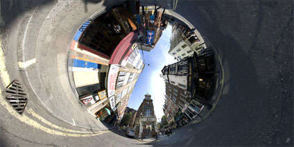
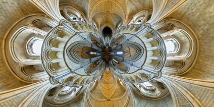
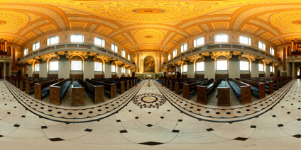
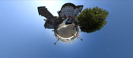
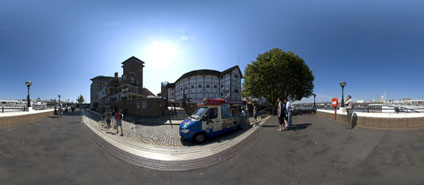
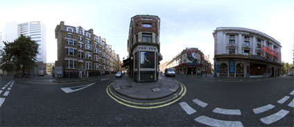
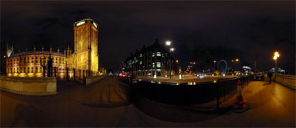
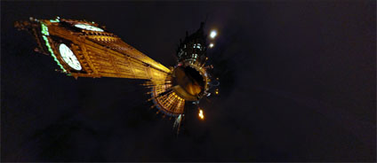
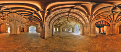
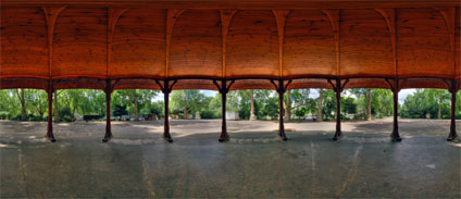
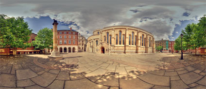
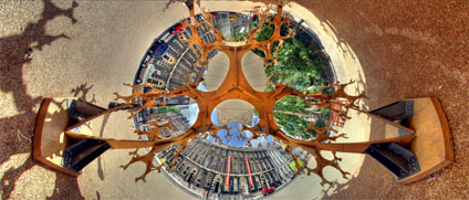
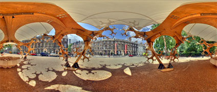
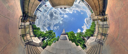
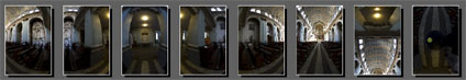
We note that the automatic stitch function is only one aspect of both Stitcher and PTGui but from our point of view, and to compare the output of all the images in this blog, we are interested in 'out of the box, point and click' functionality. To compare the two packages we loaded in a set of images of St Peters Church in Soho, London which were captured with a Precision 360 panoramic head and a Nikon D70 10.5mm lens.


Both Stitcher and PTGui recognise the cameras EXIF data so there is no need to enter any lens parameters, as should be the case for a point and click automatic stitch setup.


The Stitcher interface is clean and intuitive; it is simply a case of loading the images in, accepting the EXIF data and selecting 'AutoStitch'. PTGui is similarly straight forward although the interface is not quite as intuitive. We don’t intend to go into depth on the in's and out's of the packages but concentrate on the automatic output which is the important aspect in our current work flow.

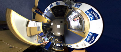
This is sadly where Stitcher Unlimited 5.5 falls down. The company must realise that it is going to be compared directly against the likes of PTGui, to such an extent that posts on their forum mentioning the package are now banned. If this is the case you would of thought that RealViz would of made sure that Stitcher works 'out of the box', and in our tests this was simply not the reality of the situation.


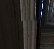
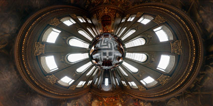
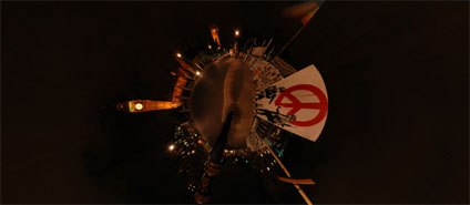
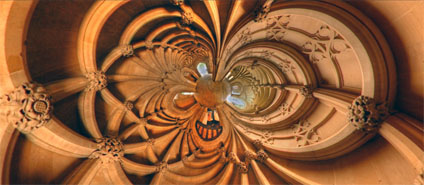
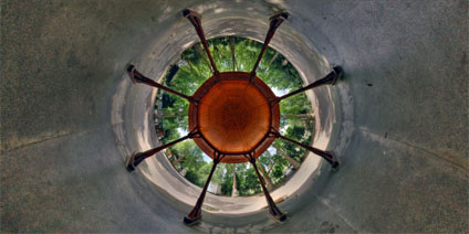
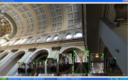
Pictured above is a selection of errors in the output from Stitcher. The images speak for themselves and resulted in a panorama which was unusable, PTGui on the other hand, stitched the images with no notable errors that could be detected. Render times are also of note with Stitcher creating the panoramic scene in 6.47 minutes compared to PTGui's 3 minutes and 50 seconds.

We are aware that reviews on the web are subjective and often opens oneself up to criticism. However, in our view, Stitcher should be able to compete with the much lower priced PTGui on the autostitch functionality. To find that it doesn’t is disappointing to say the least and you have to ask yourself what is RealViz doing releasing a package that it knows does not hold up to comparison with the competition which is less than a quarter of the price.

We like RealViz, they create some innovative software but Stitcher Unlimited 5.5 falls short and we can’t understand why.


Urban Simulacra London Paper

Recently we published the article 'Urban Simulacra London' in Architectual Design - Sensing the 21st-Century City: Close up and Remote.

As the digital revolution deepens and pervades every aspect of daily life, virtual realities begin to penetrate one another in a multiplicity of ways. The amount of sensing data being compiled on the city grows, enabling the construction of virtual realities that can, in turn, be transformed for diverse purposes.

Here, Michael Batty and Andrew Hudson-Smith from the Centre for Advanced Spatial Analysis, University College London, outline how they went about the construction of a virtual city in central London.

A conventional 3-D-GIS/CAD model was used as the basis on which to build a digital realm in which designers are cast as avatars and populations as agents, so as to define new ways in which to understand and plan the city.

You can read the article here (7Mb PDF). The original journal can be purchased from Wiley.

Full Reference: Batty, M., and Smith, A. (2005) Urban Simulacra: From Real to Virtual Cities and Back and Beyond, Architectural Design, Sensing the 21st Century City: The Net City Close-up and Remote, David Grahame Shane and Brian McGrath (Editors).

2006-07-30

The CASA Book of GIS

We forgot to mention it on this blog before now but for those interested there is The CASA book of GIS which describes cutting-edge developments in GIS applications at University College London's Centre for Advanced Spatial Analysis (CASA). Drawn from archaeology, architecture, cartography, computer science, environmental science, geography, planning, remote sensing, geomatic engineering and transport studies, these applications are emerging as the basis for spatial decision support systems across a wide range of industries and jurisdictions.

Accessible and innovative, these projects show how spatial analysis is essential to solving problems and creating insight into how people live and how their quality of life can be enhanced.

It includes a couple of chapters featuring earlier work from this blog and provides an interesting insight into the development and applications of GIS and visualisation in general. A link to the book via Amazon can be found in the side bar.

Ed's Diner/Three Greyhounds and Mary Poppins London Panorama


Ed's Diner is located in Soho in London. Based on the Apple Pan Diner in Los Angeles is was established in 1987 and features a retro 1950's decor.

Panning around the scene you will see the Three Greyhounds Pub in Greek Street. Featuring a mock Tudor exterior which has been recently restored.

Finally of note is the Cameron Mackintosh production of Mary Poppins at the Prince Edward Theatre in Old Crompton Street. View the panorama of Ed's Diner/The Three Greyhounds and Mary Poppins, London (2.9Mb).

2006-07-28

High Definition (720p) Historic London Panorama Movie


Sometimes you sit back and think to yourself, wow this is makes it all worth while. Panoramas on their own can be impressive but when you render them in High Definition and link them to Mozart's Requiem Mass in D minor the movie raises the bar on what we thought possible.

As we noted previously our movies were rendered in DVD quality, or 720x480 resolution. Using a custom profile it is now possible to export via the simple to use (and more importantly rapid to export) Windows Movie Maker at 1280 x 720, or 720p High Definition.


The movie in High Definition features The Chapel of Peter and St Paul by Wren, Southwark Cathedral, The Painted Hall by Wren and St Giles in the Field.

You can download the movie here (80Mb, WMV), we recommend you have your headphones on or sound system operational as the sound track enhances the flythrough.

Any comments on this would be most welcome...

2006-07-26

Rendering High Definition WMV for Visualisation


With the arrival of new High Definition screens visualisation techniques need to be upgraded to ensure the quality is upheld when outputting to a Plasma, LCD or other High Definition capable device.

Previously our movies were rendered in DVD quality, or 720x480 resolution. Using a custom profile it is now possible to export via the simple to use (and more importantly rapid to export) Windows Movie Maker at 1280 x 720, or 720p High Definition.

Our first example of the Painted Hall in Greenwich is available for download and illustrates the increase in quality possible (20mb .wmv). More examples can be found at the Windows High Definition Showcase site.

The increase in resolution does however come at the price of an increase in render times out of 3DMax for the movies. We are currently re-rendering the 'Step Inside' Panorama movie of London which can be seen on this blog via YouTube. Currently its looking like a 42 hour render, but as soon as its ready we will make it available for download.

'There' - The 'There' Metaverse

Following our First Steps in Second Life post we have created a similar movie documenting our entry into the Virtual World system known as 'There'


In the same way as Second Life, 'There' now has free registration so you can log into the environment without having to type in your credit card details. 'There' is described as 'an online getaway where you can hang out with your friends and meet new ones--all in a lush 3D environment that's yours to explore!' As the movie illustrates 'There' has a more cartoony look than Second Life and is all the better for it. There is also the option of 'Premium Membership' for $9.95 which includes Voice Chat and various other upgrades, although the free account is quite adequate for first steps and getting to know the world.

As ever with these worlds we are interested in importing our own objects, we are looking into this and if we manage it will of course post details along with another movie. 'There' is free and if you look beyond the 'fun' element and into the possibilities for collaborative visualisation and architecture then it offers a number of interesting options.

2006-07-25

City Life - First Steps in the Render Engine

The interesting part of the game City Life is its rendering engine and the ability to import your own buildings direct from 3D Max.

We had to mention that first as loading a game up during office hours has been greeted with calls of 'he gets paid to play games' and 'I thought only 10 year olds used video games'. You would of thought researchers, especially in this field, would know better but sometimes you just have to shrug and realise that your on to something that others can't see.


If we can load some of Virtual London models into City Life and use the game engine to automatically populate it and allow real-time flythroughs then the 'game' suddenly becomes interesting. The movie above illustrates our first steps in City Life and should provide an insight into the visualisation possibilities.

Now if this render engine linked with Google Earth? This is how we would like to zoom into cities with the locations populated with avatars - a mix of Google Earth/City Life and Second Life.. thats the killer application for city visualisation.

May Thou Have A 99 - Globe Theatre and Ice Cream Van London Panorama


The original Globe Theatre was built in 1559 Southwark, on the South Bank of the Thames. The theatre was subsequently closed by the Puritans in 1642 and destroyed in 1644.


The new Globe Theatre opened in 1997, located 200 yards from the original site with the first thatched roof building permitted in London since the Great Fire of London of 1666.

You can find out more about the Globe from the offical site.

View the panorama of the Globe Theatre, London (2.9Mb).

2006-07-24

Brian Haw's Peace Protest/Banksy Canvas London Panorama


The panorama was taken to capture Brian Haw's Peace Protest at Parliament Square, London, before police mounted a massive night-time operation to dismantle the display on 23 May 2006. The centre of the panorama featured a canvas by the artist Banksy.

Taken from Brian's website - Initially he was campaigning against the economic sanctions on Iraq and the bombing of the country by the US and UK. After 11 September 2001, he widened his focus, directing his messages of peace against the 'war on terror', the terror that the US and UK have inflicted on Afghanistan and Iraq. He protests on behalf of those innocent people who suffer and die in other countries, as our governments seek to further their own economic, military, politcial and strategic interests around the world.


View the panorama of Brain Haw's Protest, London (2.9Mb).

The Ivy London Panorama


The Ivy Restaurant in London was relaunched in 1990: the architect M J Long carried out the extensive refurbishment, with leading contemporary artists commissioned to create site-specific works. Restored to its former glory, it now seems firmly established as London’s favourite theatre restaurant.

“A table at the Ivy is one of the most sought after pieces of furniture in London.” AA Gill.

View the panorama of The Ivy Restaurant, London (2.9Mb).

2006-07-23

Globe 4D - Make Your Own Real Google Earth (?)

Globe 4D is a unique research project from Leiden University in the Netherlands. Essentially it consists of a data projector mounted above a plastic sphere which is in turn linked to a track ball and a mouse. With the sphere linked to the track ball Globe4D is able to display dynamic images which can be viewed from all angles. Combining this with a turntable, linked to a mouse, it is also possible to display geographical data over time. The movie below gives an insight into its construction and use:


What is interesting about the project is how simple yet effective it is. Of note is the lack of zoom facility, but if you could get Google Earth to change its projection (so it can be beamed onto a sphere), then you could easily make of these at home. The concept of zooming becomes problematic of course but one that could be worked around....

2006-07-21

Google Earth Warehouse Comes of Age - London

The combination of providing a free version of Sketchup and the ability to publish to the Google 3D Warehouse has created a plethora of models from locations around the world. London has attacted a number of buildings, most notably for quality has been the concentration around Canary Wharf.


Using FRAPS we have loaded up the models created by a user on the 3D Warehouse known as Jef and created the movie above illustrating the developments so far. We haven't been able to get hold of a email for Jef.. so if you know him drop us a line (via the link on the side bar) as we would love to get in contact. You can download Jefs models from here.

As a side note this is our first test movie using FRAPS and it does not seem able to capture the info boxes in Google Earth, we will be looking into this and a number of new examples combining Google Earth and our Panoramic Globes movie will be posted soon.

2006-07-20

Digital Urban - The PhD Thesis

The complete thesis behind Digital Urban is now available online, providing an insight and working examples of the research and background behind the posts on the Digital Urban Blog..

Planning is about communication, the communication of space and place in relation to built form. The advent of digital networks provides the opportunity to radically change the concept of communication within not only the urban planning system but also wider fields related to the development of the built environment.

How we communicate is increasingly becoming digital and the rise of the Internet in particular during the last decade has freed planning from the constraints of working hours and the reliance of specific locations and times to portray information.

Information can now be visualised, communicated and manipulated at any location, any place, at any time, as long as we have the political, cultural, and economic means that gives us access to the relevant technologies. These technologies are on the edge of a new revolution in our ability to design, communicate and plan at a distance.

The revolution on the horizon is one of inhabited virtual place; a place where the environment is represented digitally in three dimensions and communication is achieved through avatars, defined as an individual’s visual embodiment in the virtual environment. Avatars in these emerging environments are the stakeholders, the occupants and the commuters of the digital realm. As such they are also the citizens that will design, occupy and manipulate built form in the development of digital planning and they will have a say in the future planning process. These developments contribute towards a digital, ‘Online’ planning system, which is explored in a series of working examples throughout the thesis.

You can read the Thesis here (15Mb PDF).

Photorealistic Buildings and Collaborative Architecture - ActiveWorlds


Active Worlds
(AW) is a 3D virtual reality environment in which we have carried out a number a projects involving collaborative architecture. Within ActiveWorlds users, represented as Avatars, can chat with one another or build structures and areas from a selection of pre-made objects.

The unique feature of ActiveWorlds, when for example compared to Second Life, is the ability to import objects into the environment. This allows photorealistic buildings, modelled as part of Virtual London, to be added to the object set and placed/moved/deleted by individuals or groups working on a collaborative build.


The movie above illustrates some sample houses, typical of the new build UK housing stock, being imported and manipulated in ActiveWorlds. The system is database linked so in theory it could be linked to a Geographical Information System (GIS) to create a Multi-User GIS. As CAD is increasingly becoming group/collaborative based, there is potential in linking CAD/GIS and a multi-user Avatar based system. With regards ActiveWorlds, linked with say ESRI ArcMap, it should (in theory) also be quite straight forward.

2006-07-19

Record July Temperature and New Carpets

A combintation of a revamp of the office to lay new carpet and a conference in Munich on Digital Europe means there wont be any posts until Thursday or Friday this week.

We have a good one coming up though on using the render engine in 'City Life' to import models.. more as soon as the concrete drys in the office and the carpet can be fitted!

As a side note the record temperature for July in the UK looks to be broken today, it currently stands at 36C (97F) at Epsom, Surrey in 1911. You can view temperature live from our roof, updated every 3 seconds.

2006-07-14

Houses of Parliament London Night Time Panorama


An example of Gothic Architecture the Houses of Parliament were constructed between 1840 and 1888. The panorama is taken outside the main tower near Westminster Bridge and the River Thames.


The tower stands 320 foot tall and is named after the largest bell, 'Big Ben' which weighs over 13 tons, and was cast in 1858 at the Whitechapel Bell Foundry in East London.

View the panorama of the Houses of Parliament at Night, London (500K).

Inns of Court, Lincoln's Inn Field London Panorama


The panorama is captured in front of the Old Hall at Lincoln's Inn Fields 'Inns of Court'. The 'Inns of Court' were founded in the beginning of the fourteenth century and Lincoln's Field is one of four in London.


According to ancient custom anyone training to be a barrister in Britain must join one of the Inns of Court and dine there 24 times, as well as passing their examinations, before being officially qualified.

Of note are the alumni of Lincoln's Inn which include Oliver Cromwell, John Donne of whom you can find out more in our Lincoln's Inn Chapel Post and William Penn, founder of Pennsylvania.

View the Quicktime panorama of the Inns of Court (3.1mb).

2006-07-13

Lincolns Inn Fields Chapel London Panorama (High Dynamic Range)


The Chapel in Lincoln's Inn Fields dates back to 1623. The Chapel bell pre dates the Chapel at 1596 and is the source of the quote from John Donne of 'for whom the bell tolls'.


Donne noted this as it was the custom to toll the bell between 12.30 and 1.00 p.m, when news of the death of a bencher was received.

View the Quicktime panorama of Lincolns Inn Fields Chapel (3.1mb).

2006-07-12

Lincolns Inn Fields London Panorama (High Dynamic Range)


Lincoln's Inn Fields is the largest square in London and was once a place of public execution. Executions took place during the Tudor and Stuart periods with many religious martyrs, and those suspected of treachery to the Crown, meeting their end.


Thanks to a decree dating from the 1640s, the green area was preserved for generations of Londoners.

The panorama is taken from the BandStand in Lincoln's Inn Fields park.

View the Quicktime panorama of Lincolns Inn Fields Bandstand (3.8mb).

Smooth FM Studios - London Life Panorama


Digital Urban captured the studios of Smooth FM after a conversation with one of its DJ's Kevin Greening. It is part of hopefully a series of panoramas giving an insight into the media that contribute to London's airwaves and life in general.

If you work in the media and would like a panorama taken (its free!) then get in touch via our contact us link above.

Smooth FM can be picked up on DAB in London, Central Scotland, North East England, Yorkshire, West Midlands and South Wales/Severn Estuary.

View the panorama full screen in quicktime virtual reality (Click and Drag to Look Around)

Templar Church London Panorama (High Dynamic Range)


Templar Church, located off Fleet Street in London is so called as it was built by the Knights Templar, the order of crusading monks founded to protect pilgrims on their way to and from Jerusalem in the 12th century. Templar Church was consecrated in 1185 to as the Templar's headquarters in London and was built in the image of the Church of the Holy Sepulchre in Jerusalem.

Sadly we were not allowed to photograph inside the church as there need to 'protect their commercial rights'. We fully understand this of course, its interesting that as soon as a photograph becomes a panorama it becomes increasingly difficult to get permission.

As a final note this is another High Definition Range (HDR) Panorama, HDR is a useful technique for areas of shade and light contrasts but in general daylight we are not sure it works. The panorama, which you can view below, is nicely lit but HDR, through Tone Mapping, seems to give the shots a slight 'fake' look. The jury on this is out at the moment, I guess its a personal preference....

View the Quicktime panorama of Templar Church London (3.2mb).

2006-07-11

Architectural Association Summer Pavilion - London Panorama (High Dynamic Range)


Taking up temporary residence in Bedford Square London is the Architectural Associations Summer Pavilion by Simon Whittle.


Built in Finnforest timber the structure makes a striking contrast to the square which has just undergone a 6 month regeneration as part of the Bloomsbury Squares project. The Square is one of the best preserved set pieces of Georgian architecture in London with numerous Grade I listed buildings.

View the Quicktime panorama The Summer Pavilion (4.5mb).

Cleopatra's Needle London Panorama (High Dynamic Range)


Cleopatra's Needle is located on the Victoria Embankment in London near Waterloo Bridge. The Needle is one of a trio of Needles around the world, the others being in Paris and New York. Presented to the United Kingdom in 1819 it commemorates the victories of Nelson in the Battle of the Nile and Sir Ralph Abercromby in Battle of Alexandria.

On either side of the Needle are two bronze Sphinxes, the right hand Sphinx still bares the shrapnel holes from a German air raid on London.

Of note in the panorama is the state of the area surrounding the Needle - from milk bottles to rubbish bags to broken glass its nice to see Westminster Council is looking after London during these summer tourist months.

View the Quicktime panorama Cleopatras Needle (3.2mb).

2006-07-10

Virtual London - The Flythrough Movie

Below is the flythrough movie of Virtual London circa 2005 by CASA. Created using a mix of high resolution panoramas, ray tracing and of course the 3D model it provided a phase one demonstrator. The models extent now extends to the M25.

- Note as with most of our movies they now contain audio -


Research work continues on rapid photomodelling and of course we have it in Google Earth but are still working on the licensing issues...

Any thoughts or comments on the flythough are of course welcome..

Visualising Las Vegas - Second Life

Following our own first steps in Second Life, documented in the video below, it is worth expanding this to look at the creation of real world cities.


The movie below by Sufis Angel, demonstrates the construction, using a collaborative tool set, of Las Vegas. Sadly Second Life does not allow the user to import their own models when compared to, for example, ActiveWorlds. It does however allow texture import, a set of facade photographs could easily be imported from say our London dataset to construct sections of the city in Second Life.


As has been mentioned before if you merged Second Life with Google Earth you would have a killer application...

If you have Second Life installed you can teleport direct to Las Vegas

2006-07-07

Stupid Thing to Do on a Friday in Google Earth - London Bus


Ok so this is a bit an academic blog, but sometimes on a Friday when its warm outside and your working on an easy route from 3DMax to Google Earth you just click the 'place' button and see where the model lands.

In our case the model landed in Mid America and raised a smile so if you want to see the number 134 London bus from North Finchley on its way to New Mexico then click the file download below.

On a more serious note it shows how not only building models are of use when photomapped and if we can get some sort of animation system running on route paths it might be possible to get buses driving round London. If you could then link them with the GPS feed then it suddenly become a real-time transport model but thats some way off.

You can download the kmz file to fly into the model in Google Earth here (6mb)

Extracting Geometry from a Painting - 3D Art/Virtual London circa 1616


Maybe it just us, but we sometimes look at paintings and think wouldn't it be great to flyinside that scene. So, using a section of Visscher's panoramic view of London circa 1616, we put in lines of perspective and traced around the main features.


As the movie above shows you can then create a 3D flythough or indeed a full 3D model. We also put the painting into ActiveWorlds with avatars a while ago and its kind of interesting to not only have 3D art but also see people walking around a picture.

This would seem to be of use for multimedia applications in galleries etc... its neat but seems to be one of things that sits on our hard drive and never gets out of the lab.. still least now its on YourTube.. Soundtrack is Beethoven, Sonata nr.8 in G-Major btw.

Comments as ever welcome...

2006-07-06

High Dynamic Range Panoramas - UCL Quad


University College London was founded on February 11th 1826, the third University in the United Kingdom after Oxford and Cambridge.

The Universities main building, pictured in this panorama, was designed by William Wilkins and constructed between 1827 and 1828. The building is centered on a Corinthian portico which is reminiscent of the British Museum, (constructed a couple of years earlier).


After the building of University College London Wilkins went to design the National Gallery in Trafalgar Square.

View the Quicktime panorama of The University of London Quad, London (3.2mb).

Collaborative Avatar Room


Before the demise of Adobe Atmosphere we built a collaborative avatar based environment whereby users could log in, view models and move objects around the room whilst commenting on various scenarios.


Before building the world in Atmosphere the room is generally visualised in 3D Max first, allowing the model to imported into other software packages as and when they come along. The movie above shows the last London Planning Room concept, all that is needed now is a new multi-user system to import it to... the wait for a new Adobe Atmosphere continues...

London 3D Air Pollution Movie

At CASA, in association with the Environmental Research Group at Kings College London, we have created a 3D map of London, overlayed on our 3D Model.


The aim of the movie is to demonstrate how, compared to a traditional 2D map, it is easier to gain a 'sense of location and place' and thus communicate data with a 3D surface. The whole 2D/3D thing is debatable of course... you can view a mix of 2D and 3D views on the Air Pollution website and some more info and contact details on the CASA news item.

2006-07-05

3D London Tube Map


A while ago we built a map of the London Tube network.. its neat but to be honest not all that much use (?). Somewhere on our hardrive is a real location of the map in 3D as well, we will hopefully dig that back out in a few days. You can view the current 'classic' London Tube Map below:


The reason for the post? We were going to add in depth data to produce a real representation of the tube network. Sadly due to security fears (which are understandable to say the least) this looks like it wont happen. Still, it would of made a neat flythough...

A higher res version can be found can be viewed from here (23Mb). Note the movie uses the DIVX codec.

Adobe's Virtual World - City Visualisation and Learning

Before the sad demise of Adobe Atmosphere, a Virtual Environment system which had a lots of potential, we created a Virtual London world. The world was hosted on the London Grid for Learning and aimed at providing information on the city direct to classrooms with teachers notes etc. A clip of the 'photo gallery' section of the world can be seen below.


The movie clearly demonstrates how such software can be used to construct worlds which aid the learning and teaching process. Sadly Adobe announced the closure of Atmosphere on the launch day of our project which was not to be honest all that well timed.

To date there has not been another system that allows one to import 3D models, although Pelican Crossing is one we are watching closely.

2006-07-04

London Churches 'Step Inside' Panoramas

We like this one, ok so it sounds like self congratulations but hey how hard is it to gets comments and hits on a site (it seems hard!)... Anyway this is movie 3 in the series of 'step inside' panoramas with Ray Tracing in 3D Max and set to Requiem by Mozart.


Thoughts/Comments maybe, oh its ok we will keep ploughing on anyhow :)

For a higher res version, or if your having problems with YouTube you can download the movie (.wmv, 8Mb)

London - Movie 'Step Inside Panoramic Globes' 2

Continuing the experiments into 'step inside' panoramas
we have posted another movie below that takes in the sights of Leicester Square, Tower Bridge, Covent Garden and others. Made in the same style as the previous post it places high resolution panoramas in an x/y/z space allowing the user to 'step inside' them.


The movie has some basic shadows on the floor as a test, this however seems problematic due to issues casting shadows onto a globe and the resulting distortion. Various lighting issues also need to be fixed, but we hope you get the general idea....

2006-07-03

Live Weather Conditions - London


* An update to the post with a new URL at the bottom - Data is uploaded every 2 seconds*

Digital models should reflect the reality of the city, not only the urban form but also environmental conditions - such as the weather. Digitalurban has mounted a wireless weather station on our roof, it provides a myriad of data and is updated every two seconds. It is then possible to embed this data in a web page, using Flash and a product entitled Weather Display Live.

This allows live data to be viewed via the web, with the dials tweening according to local conditions. If this data - or an overview of - such as Sunny, Rain, Partly Cloudy etc could be linked to a 3D model, it would enable it to accurately reflect local conditions. If a number of weather stations are linked up, they could be used to visualise the urban heat island effect, live and in 3D. Combined with symbols and locations for rain fall etc this would provide a live temperature gradient and other weather data in a unique visualisation.

Well that's the plan, for now you can view the Flash based version, live from our roof.