























Below we provide full details for 2012 entry on the new MRes in Advanced Spatial Analysis and Visualisation (ASAV). The course reflects the current state of play in geographic, urban and architectural information systems with an emphasis on visualisation, analysis and modelling. Taught at the Centre for Advanced Spatial Analysis, home of digital urban, it is an innovative and exciting opputunity to study at UCL with a MRes acting as a pathway to a PhD or further career in ASAV.
Showing posts with label ESRI. Show all posts
Showing posts with label ESRI. Show all posts



2012-05-09
ESRI CityEngine, Lumion, and SketchUp - The Ultimate City Toolkit?
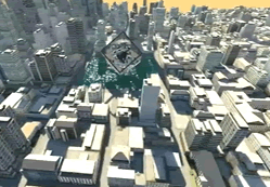
Over the last few weeks we have been looking at ESRI's CityEngine and how it can be used to create rapid urban scenes. As we noted it moves GIS visualisation a step forward while at the same time bringing procedural city modelling into the mainstream game engine world. Of course the heart of the CityEngine is the ability to import real world data but to get to grips with the interface it is sometimes easier to look at creating urban scenes from simple procedural rules.

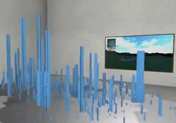
As part of the MRes in Advanced in Spatial Analysis and Visualisation, here in CASA we have been looking at various techniques to visualise urban data. One such technique is the creation of a 3D exhibition space, allowing agent based models and urban data to be visualised within an architectural space.
Music by Portoponte

As part of the MRes in Advanced in Spatial Analysis and Visualisation, here in CASA we have been looking at various techniques to visualise urban data. One such technique is the creation of a 3D exhibition space, allowing agent based models and urban data to be visualised within an architectural space.
The movie above combines the use of CityEngine in Lumion with SketchUp and 3DMax to insert an exhibition space into a city while burning the CASA logo into the street network. CityEngine is a notable step forward for ESRI, both in terms of visualisation and analysis, linking it with Lumion and SketchUp allows it to be taken even further, towards the ultimate city creation toolkit...
2012-03-20
City in a Book: Augmenting the CityEngine
Over the past few days we have been working on a series of techniques to visualise and augment procedural cities.
.JPG)
If you add in a model of a BenQ projector, the MRes in Advanced Spatial Analysis and Visualisation Handbook, a city within the CASA logo and a webcam you get the following augmented reality:
We are exploring this as part of our digital visualisation module on the MRes here in CASA, aiming to build in the latest research into the lectures. The combination of Lumion, 3DMax, Illustrator, CityEngine and AR is intriguing...
.JPG)
If you add in a model of a BenQ projector, the MRes in Advanced Spatial Analysis and Visualisation Handbook, a city within the CASA logo and a webcam you get the following augmented reality:
We are exploring this as part of our digital visualisation module on the MRes here in CASA, aiming to build in the latest research into the lectures. The combination of Lumion, 3DMax, Illustrator, CityEngine and AR is intriguing...
2012-03-19
ESRI CityEngine - Creating Cities inside Logos and Logos inside Cities
The best way to learn new modelling software is to step away from complex data and take a side look at its capabilities. We have used this approach to run through the various features of CityEngine, producing a series of movies based around the logo of the Centre for Advanced Spatial Analysis, here at University College London.
 First up we integrated the CASA logo into the cityscape by manually tracing the logo and building a network around it. Via an import into iMovie the result is a playful fly around the logo:
Taking the concept further we built the city around the logo, using the nodes and hubs as interconnected cityscapes. With the city base rising out the sea it presents a different feel to the original movie:
Finally, we used an alpha channel on the logo, allowing us to lower the outline onto the cityscape:
The combination of Adobe Illustrator, ESRI CityEngine, AutoDesk 3DMax and finally Lumion make for a rapid way to create unique cityscapes. The next steps are to integrate actual data.....
 First up we integrated the CASA logo into the cityscape by manually tracing the logo and building a network around it. Via an import into iMovie the result is a playful fly around the logo:
Taking the concept further we built the city around the logo, using the nodes and hubs as interconnected cityscapes. With the city base rising out the sea it presents a different feel to the original movie:
2012-02-11
15 Minutes with CityEngine and Lumion....
A quick weekend post - following on from our first look at CityEngine and Lumion we have expanded the visualisation to add in various standard items from the Lumion library along with a surrounding terrain and waterside setting:
Total development time: 15 minutes with rendering 1.5 hours, its getting quicker to make cities....
2012-02-09
CityEngine: ESRI and Lumion a first look.
Yesterday a license for CityEngine landed on our desk from the nice people at ESRI and to be honest we were a little too excited for our own good, after all its only software. However, CityEngine and its integration with ESRI ArcGIS, while maintaining full export capabilities to load into 3DMax/Lumion/Unity etc, is a game changer.

It moves GIS visualisation a step forward while at the same time bringing procedural city modelling into the mainstream game engine world. Over the coming weeks we will be putting the software through its paces and exporting into Max/Lumion and Unity as part of introducing CityEngines onto our MRes in Advanced Spatial Analysis and Visualisation. The clip below details out first output direct from CityEngine into Lumion, adding in a general landscape, sample trees and transport objects:
Linking in our previous post on ArcGIS Twitter Visualisation in Lumion it seems that the worlds of GIS and architectural visualisation/game engines are finally starting to become accessible.

It moves GIS visualisation a step forward while at the same time bringing procedural city modelling into the mainstream game engine world. Over the coming weeks we will be putting the software through its paces and exporting into Max/Lumion and Unity as part of introducing CityEngines onto our MRes in Advanced Spatial Analysis and Visualisation. The clip below details out first output direct from CityEngine into Lumion, adding in a general landscape, sample trees and transport objects:
Linking in our previous post on ArcGIS Twitter Visualisation in Lumion it seems that the worlds of GIS and architectural visualisation/game engines are finally starting to become accessible.
2012-01-21
London's Twitter Island - From ArcGIS to Max to Lumion
As part of the MRes in Advanced Spatial Analysis and Visualisation, here in CASA at The Bartlett, University College London, we are exploring new methods and techniques for visualising data. As part of the course we are looking at collecting data from the Twitter API and using the resulting .csv file as an input into a variety of software, including Processing and ArcMap.
 One such known example is the London Twitter map by UrbanTick, developed using the data collector created by Steven Gray and imported by Fabian into ArcMap, it developed a style of its own as the 'NewCity Landscape' collection. From a digital urban point of view the next stage of the map is a 3D extension, a transformation that proved surprisingly difficult due to the nature of combining the worlds of traditional GIS and game engines such as Lumion.
We are still in the early stages of development but the movie below illustrates the NewCity Landscape Map of London visualisation in Lumion as a 'Twitter Island':
Music by Pigeman over at MP3 Unsigned. There are of course many arguments on the pro's and con's of visualising data in such a way, indeed the visualisation is developed to open up the debate as part of the MRes course allowing various visualisation techniques to be compared from the same data set.
We will have more updates as the visualisation develops, along with a walk through of how to build it. If your interested in such output our MRes is now open for applications, entry 2012-2013...
 One such known example is the London Twitter map by UrbanTick, developed using the data collector created by Steven Gray and imported by Fabian into ArcMap, it developed a style of its own as the 'NewCity Landscape' collection. From a digital urban point of view the next stage of the map is a 3D extension, a transformation that proved surprisingly difficult due to the nature of combining the worlds of traditional GIS and game engines such as Lumion.
We are still in the early stages of development but the movie below illustrates the NewCity Landscape Map of London visualisation in Lumion as a 'Twitter Island':
Music by Pigeman over at MP3 Unsigned. There are of course many arguments on the pro's and con's of visualising data in such a way, indeed the visualisation is developed to open up the debate as part of the MRes course allowing various visualisation techniques to be compared from the same data set.
We will have more updates as the visualisation develops, along with a walk through of how to build it. If your interested in such output our MRes is now open for applications, entry 2012-2013...
2010-07-13
Procedural/ESRI and NVIDIA: 3D Cities from 2D ArcGIS Data
Procedural and ESRI have teamed up with NVIDIA to set up a pipeline for the creation, analysis and visualization of photorealistic 3D cities from 2D ArcGIS data. The video shows the creation of the 3D model of the City of Rotterdam in CityEngine:
3D in ArcGIS has always been a bit of a love/hate affair with us so the ability to create a workflow that includes the CityEngine is an intriguing development.
3D Rotterdam in the cloud: http://www.procedural.com/showcases/rotterdam.htmlNVIDIA
RealityServer: http://www.mentalimages.com/products/realityserver.html
ArcGIS 3D Analyst: http://www.esri.com/3d
3D in ArcGIS has always been a bit of a love/hate affair with us so the ability to create a workflow that includes the CityEngine is an intriguing development.
3D Rotterdam in the cloud: http://www.procedural.com/showcases/rotterdam.htmlNVIDIA
RealityServer: http://www.mentalimages.com/products/realityserver.html
ArcGIS 3D Analyst: http://www.esri.com/3d
2010-03-31
flutter: Realtime Social Media Mapping
We are always wary of any description text that states 'one of the most interesting things you'll watch all day' but it is actually a really neat movie and product, so we'll let the marketing department off this time - flutter:
Written in Adobe Flex, the application mashes up ESRI's ArcGIS Online mapping services with some of the most popular media feeds available today: Twitter, Flickr, & YouTube. The music leaves us waiting to see 'Matt' as it seems to the same track used in http://www.wherethehellismatt.com/ which kind of takes the focus away just a little bit.
See http://www.dbmediastudio.com/samples/mashup/ to see it running live, its quite hypnotic to watch.
Written in Adobe Flex, the application mashes up ESRI's ArcGIS Online mapping services with some of the most popular media feeds available today: Twitter, Flickr, & YouTube. The music leaves us waiting to see 'Matt' as it seems to the same track used in http://www.wherethehellismatt.com/ which kind of takes the focus away just a little bit.
See http://www.dbmediastudio.com/samples/mashup/ to see it running live, its quite hypnotic to watch.
2009-03-28
ESRI and Microsoft Team up for ArcGIS 9.3.1
We knew this was coming and indeed it was possible via other routes but its still quite a notable move with ESRI teaming up with Microsoft to offer Virtual Earth directly within ArcGIS. The full announcement is below:
ESRI Expands Virtual Earth Access in GIS by Teaming with Microsoft
ArcGIS Users to Bring Dynamic Basemaps into Analysis and Service Applications
Redlands, California—March 26, 2009— ESRI announced today a new agreement with Microsoft Corporation that gives ArcGIS users fast access to Microsoft Virtual Earth for their geographic information system (GIS) projects. As part of ArcGIS Online at the ArcGIS 9.3.1 release, ArcGIS Desktop and ArcGIS Server users will be able to connect directly to Virtual Earth and quickly start their GIS projects with ready-to-use content.
"Our agreement with Microsoft defines a pattern of sharing geospatial data on the Web that promises to grow the GIS community," says ESRI President Jack Dangermond. "By bringing Virtual Earth into their GIS projects, people will have a greater opportunity to perform spatial analysis based on dynamic data."

ArcGIS users who are current on maintenance and have an Internet connection will have access to Virtual Earth for a variety of up-to-date mapping content.including aerial imagery, roads, and hybrid (aerial with labels) imagery. With a familiar look, imagery access will appear as another data layer in GIS. The imagery will provide excellent background maps on which users can overlay their operational data. This means users will be able to focus more on their business data than on its context.
For example, an electric utility can layer its distribution line data over a Virtual Earth aerial view of a neighborhood to create a map of its lines and customer connections. This Virtual Earth background layer is useful for editing the company's data and can be easily shared online with other company users.
ArcGIS users can build Web applications that support geospatial services through ArcGIS Server and ArcGIS Web Software Developer Kits (SDKs) , including APIs for JavaScript, Flex, and Microsoft Silverlight. This enables them to provide their clients with access to Virtual Earth content from their applications.
“ESRI and Microsoft share a long history of building geographic information systems solutions that combine both of our companies’ strengths,” said Chris Sampson, director of Virtual Earth at Microsoft. “By integrating Microsoft Virtual Earth across all ESRI ArcGIS products, we can provide our mutual customers with spatial analysis software that has instant access to comprehensive geographic data that can only be found in a software plus services solution.”
ArcGIS Desktop 9.3.1 users who are current on maintenance will be offered access to Virtual Earth at no cost. ArcGIS Server 9.3.1 users will have instant access to a built-in 90-day evaluation of Virtual Earth. After the evaluation ends, ArcGIS Server users will be able to purchase an annual subscription that will be based on transactions.
For more information, visit www.esri.com/agolwhatsnew.
2008-11-12
Embed Virtual Earth into ESRI's ArcGIS
The excellent Arc2Earth from Brian Flood has always had the ability to display map tiles from Microsoft, Yahoo and Ask.com as a custom layer in your map.
What is new in the current beta release is the ability to directly embed the API from Microsoft and Google into ArcMap - the movie below explains all:
<a href="http://video.msn.com/video.aspx?vid=e9a8d421-7e9c-4544-848f-568a948e4410" target="_new" title="Arc2Earth - Virtual Earth">Video: Arc2Earth - Virtual Earth</a>
As brian states on the Spatial Data Logic Blog, you can drape your own data over the existing globes and then use this as an element on your Page Layout for exporting to either paper or digital copies. The process of draping your current map over the globes happens automatically and on a background thread, so its really intuitive to work with and doesn’t stall the main thread ArcMap uses for most of its own work . As you change your Map contents in the TOC, the changes are reflected on the globes as well.
Find out more via http://www.arc2earth.com/
What is new in the current beta release is the ability to directly embed the API from Microsoft and Google into ArcMap - the movie below explains all:
As brian states on the Spatial Data Logic Blog, you can drape your own data over the existing globes and then use this as an element on your Page Layout for exporting to either paper or digital copies. The process of draping your current map over the globes happens automatically and on a background thread, so its really intuitive to work with and doesn’t stall the main thread ArcMap uses for most of its own work . As you change your Map contents in the TOC, the changes are reflected on the globes as well.
Find out more via http://www.arc2earth.com/
2007-12-14
Geographic Data in Second Life

Now we have a route from ESRI's ArcMap into Second Life it opens up all sorts of possibilities for importing geographical data into an environment that is ripe for public participation and collaboration type outreach activities.
The movie below details various population data sets displayed per London Borough, it is still beta but we think it shows potential:
Music by New Inception
If you have Second Life installed you can visit us by clicking here - you will get a red arrow pointing skywards, simply fly up to our section of Second Nature island.
If you do not have Second Life then we thoroughly recommend downloading and popping by for a visit.
2007-11-30
Arc to Second Life: Geographic Data Direct to Second Life
 As part of our research project funded by the National Centre for E-Social Science we are working on Second Nature Island (part of the NATURE group) on importing geographic data into Second Life.
We have just made a bit of a break through by importing data direct from a Geographic Information System (GIS) into our section of the world. As the Centre for Advanced Spatial Analysis the majority of our data is held in ArcMap, a GIS package made by ESRI.

The two images (each clickable for larger versions) illustrate the 32 London Boroughs extruded according to their embedded data. Each Borough can be queried and more importantly can now be visualised in Second Life.
It is still early days but an exporter from ArcMap to Second Life would be a unique step in the aim to share geographic data in collaborative environments.
Thanks go to Joel at CASA for writing the scripts.
Subscribe to:
Posts (Atom)