CityDashBoard TalesofThings MapTube
Qrator Tutorials About Digital Urban
MRes ASAV SurveyMapper Contact Us

2006-02-28

Hidden London Series - London Roof Tops


We generally experience the city from street level - the streetscape defines our view of the urban space - yet if it were possible to access the hidden rooftops and terraces of homes and offices we would obtain a completely different perspective.

In a new series of panoramas we aim to capture and share such rooftop views from various buildings and houses in and around London.

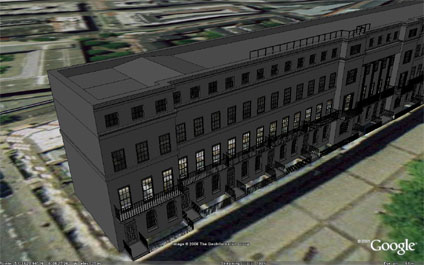
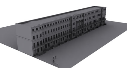
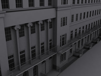
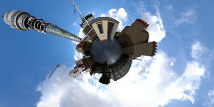
Starting off we present the rooftop of Regents Residences in Fitzrovia London. Built in 1870 the building is now dominated by the BT Tower yet retains the charm of Victorian buildings. The rows of chimney pots drift back to an era when London was dominated by coal fires in each room and the smog that resulted before the Clean Air act of 1956.

Rooftops are not easy to access and we need your help - if you work in an office and can get us access to the roof for 10 minutes then we can capture a panorama and build up a series of hidden London views. If your willing to help please drop us a email and we will get back to you asap.

Each of the views are presented in Quicktime VR, simply click the mouse in the scene and drag to look around.

View the Quicktime panorama of Regents Residences Rooftop, London (1.4mb).

2006-02-26

Thanks

Thanks for submitting the contact form, we will get back to you as soon as we can :)

Andy

Digital Urban

2006-02-25

ArcGIS Explorer - Facade Mapping and Intergrated Analysis Tools


David Maguire of ESRI Inc. gave a run through of the current beta release of ArcGIS Explorer at the Spatial Literacy in Teaching Day held at the Royal Geographical Society, London. After Googles success with Google Earth the development of ArcGIS Explorer was inevitable but the interest is in how ESRI is distancing itself from the Google Market towards the professional GIS community.

This is not a surprise in itself but by moving towards spatial analysis over the web it paves the way for opening up the world of GIS analysis to the masses. There are a number of notable features in ArcGIS Explorer, firstly the inclusion of over 700 analysis models allowing queries relating to, for example, view sheds to be run within the system. While this is a no brainier for users of the Arc Desktop line of software it is an eye opener when you realise that you can put this on every desktop of every local authority.

For a world of GIS which has been until now limited to people coming out of MSc courses it is moving towards opening up GIS for all and sundry, a change which could have a dramatic impact on the use of GIS in general.

Secondly a feature that we thought we would of seen in Google Earth by now is Facade Mapping. ArcGlobe already has close integration with systems such as 3DMax and SketchUp allowing textures to be pasted onto buildings, increasing the level of realism in 3D city models. The integration of this into ArcGIS Explorer is of interest to not maybe the GIS community but more towards architects and urban planners – it certainly has us excited.

As an interesting side note a view was made on Microsoft's Virtual Earth which was likened to a 'Destroyer sucking up vast amounts of data'. Google Earths current status was compared to the popularity of the now almost defunct Netscape Navigator which was quickly surpassed by Microsoft Explorer.

Time will tell what will happen when the three Digital Earths from the main players are in the market place, but with the systems free to download and use it is an interesting time in the world of Distributed Digital Environments.

Spatial Literacy in Teaching (Splint) Centre of Excellence in Teaching and Learning (CETL),is a joint initiative led by the Centre for Advanced Spatial Analysis at University College London, the University of Leicester and the University of Nottingham.

Agent Crowds in Architecture


Its all very well creating a 3D city but it needs the addition of other factors to add to the level of realism - one of these is people. A few years ago we used the ActiveWorlds system to import buildings and create an online community with avatars walking down the streets. This is fine for a few people but if you want to simulate crowds in a city scene you need to turn to agent modelling.

To date this has been notoriously tricky with a high demand on both resources and technical expertise. Which is why we are interested in the new Crowd Choreography tool called Crowd IT.

Currently available in a free Beta version it allows the visualisation of over 40,000 crowd agents in a scene. We will be looking closer into this next week and if the results are good in city models we will post a couple of movies.

If people are interested in the multi-user avatar work a couple of papers detailing the projects are also now available in PDF format:

1) 30 Days in ActiveWorlds - Community, Design and Terrorism in a Virtual World. The paper featuees as chapter 8 in the book 'The Social Life of Avatars', Ralph Schroeder (Editor), Springer-Verlag UK.

2) ActiveWorlds: Geography and Social Interaction in Virtual Reality, written with Ralph Schroeder and Avon Huxor, published in Futures, 33 (2001) 569-587.

2006-02-24

Chapel of St Peter and St Paul Designed by Wren - Greenwich Panorama


The Chapel of St Peter and St Paul can be found at the Royal Naval College in Greenwich. Of all the panoramas I have taken this is one of the most stunning due to the fabulous internal detail of the building. The Chapel was designed by Christopher Wren and Thomas Ripley but it is not in its original form as in 1779, fire gutted the building. After the fire it was redesigned by "Athenian" Stuart and William Newton creating the building we see today.

Notable features in the Chapel are the painting above the altar entitled 'The Preservation of St Paul after Shipwreck at Malta' by American painter Benjamin West. The Chapel has an open service every Sunday at 11am and is well worth a visit, it is also open to the general public during the week and over the weekend.


View the Quicktime panorama of The Chapel of St Peter and St Paul , London (2.4mb).

2006-02-21

Lost London Architecture - The Skylon Google Earth

Including the dimension of time is an interesting concept in Google Earth. Layers can be added to show the development of a city over years, months, decades or even centuries.

As such we thought it would be interesting to introduce some of London's lost architecture back to the landscape - starting off with the Skylon.

The Skylon, designed by Philip Powell and Hildalgo Moya, became the centre point of the Festival of Britain on the South Bank of London in 1951. Its design was suitably abstract and iconic giving a glimpse of the future to post 2nd World War Britain.

It was hugely popular and in some ways provides a glimpse back to how things should be done when viewed in comparison with Britain's millennium celebrations and architecture such as the Millennium Dome.

The Festival of Britain and the Skylon became a centre piece on the South Bank of London, similar to the way the London Eye is today. Sadly it was demolished in 1952 by the Conservative Government and the site is now occupied by the National Theatre.

Using Google Earth though it is possible to reconstruct the simple geometry and place it back on the skyline.


With the addition of an overlay showing the original site plans for the Festival of Britain (courtesy of The Festival of Britain site) the scale of the Festival can be appreciated.


You can download the kmz file to fly into the model in Google Earth here (11k)

2006-02-20

Fantasy London Google Earth


While we are still sorting out the license for real London data we thought it would be interesting to explore the concept of a previous post 'Fantasy Architecture' in London.

We have used a sample file, created using gratuitous use of a Greeble Plugin, to illustrate the concept.

If there is a building you would like to see built in London then email us either a 3d file or even a drawing of a skyscraper that you would like to see. We will then model it and place it online, creating a database of fantasy architecture in London.

We look forward to your drawings - they can be as simple as you like..


You can download the kmz file to fly into the model in Google Earth here (300k)

To view the building in context you can download the kmz file of Natwest/Swiss Re and St Helens here (35k)

Google Earth/Digi Urban in Nature


Declan Butler has written a couple of good write ups of Google Earth and Digital Globes in Nature this month. The online news version kindly mentions this blog although sadly gets the URL wrong - its a good article though - the printed version of Nature goes into more depth and is well worth a read.

You can read the article here

2006-02-10

Fitzroy Square Update - Google Earth London


Continuing the development of in house software for rapid city capture we are working on the right hand side of Fitzroy Square. Above is a screen shot of the development so far in Google Earth.


The Google Earth .kmz will be available shortly...

2006-02-07

Little Britain - Black and White Focus Panorama


When viewing panoramas it is easy to lose focus on the subject matter and look all around the scene - after all that's why panoramas are created and placed online. If the subject matter needs to be displayed in context but focused upon then one possibility is to use colour graduation to draw in the eye of the user.

As an example we have created a black and white panorama and added a colour layer to focus the eye on the building - in this case the White Horse Building in Little Britain, London. I'm not sure if it works, but an interesting concept... (?)


View the Quicktime panorama of Little Britain, London (3.2mb).

2006-02-06

Goodge Place London Panorama


Goodge Place in London's Fitzrovia is a typical hidden side street which could so easily be walked past. It contains a number of small boutiques, a health food shop and most importantly 'Dino' which is one of the areas smallest but best coffee shops.


View the Quicktime panorama of Goodge Place, London (1.4mb).

St Particks Soho Square London Panorama


The panorama is taken outside of St Patricks Church in Soho Square, London. St Particks was one of the first Catholic churches established after the passing of the Catholic Relief Acts of 1778 and 1791.


The area around the church was grazing farmland until 1536 when Henry 8th claimed the area as a royal hunting park. The first development took place around the 1600's with Soho Square dating from 1681.


View the Quicktime panorama of St Patricks Soho Square (3.3mb).