
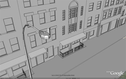
We have posted a number of models recently so we thought we would post an image of the level of detail we are working on in Google Earth London. This is a first phase test for new modeling techniques developed at CASA.
Sample high detail Google Earth files will follow shortly....
Thats... amazing.
ReplyDeleteWow! I'm impressed. How do you get such detail? Do you do it by hand from a photo? Do you have a program that interprets the photo and makes lines out of it?
ReplyDeleteVery cool!
I think you may be working on some cutting edge stuff and that in the future, perhaps all your hard work will enable blind people to see! Wouldn't that be great?!
Cheers!
now only if google earth allowed you to apply photographic textures to your models!
ReplyDeleteThis comment has been removed by a blog administrator.
ReplyDeleteThanks for the comments Dunzo.
ReplyDeleteI sadly wont be able to make the blind see - although i agree that would be great.
Victor Schinazi as researcher at our lab CASA is however researching how we can improve the blinds sense of Urban Place and Space (Spatial Cognition & Low Vision). You can view his work on his Blog at
Do you have a complete London city 3d fiel we can download and use in google earth?
ReplyDelete