CityDashBoard TalesofThings MapTube
Qrator Tutorials About Digital Urban
MRes ASAV SurveyMapper Contact Us

2005-09-30

RealViz Stitcher 5 Review vs PTgui 5.1


RealViz has released an update to its once impressive panorama stitching software in the form of Stitcher 5. The majority of the panoramas in this blog were stitched in its previous version 3.5 and as such version 5 has been hotly awaited.

It has a number of new features, including an automatic stitch mode and the ability to add control points for those difficult alignments. At $580 Stitcher has always been a 'high end' option and so we took the new version for a test drive with a series of simple test images.


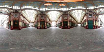
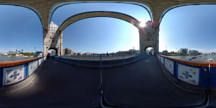
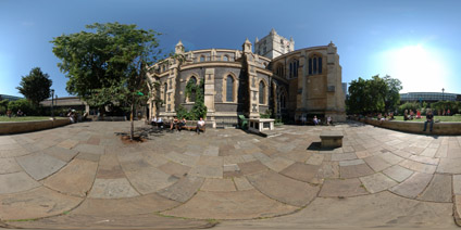
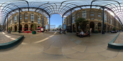
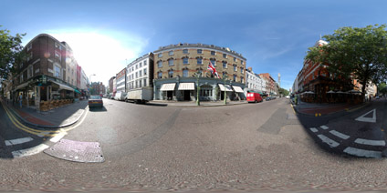
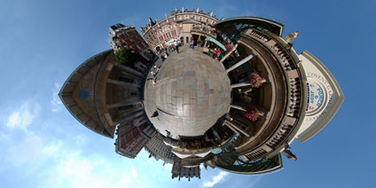
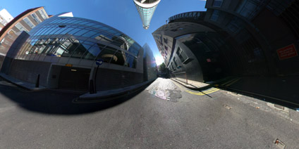
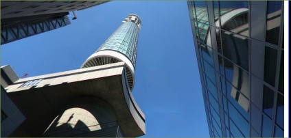
The images we used were captured outside the London Globe Theatre using a Nikon D70 and a 10.5mm lens. Due to various patent issues RealViz is not able to stitch such wide angle images directly so they we 'defished' beforehand using Nikon Capture 4.1.

Once loaded into Stitcher the first thing one notices is its new interface, allowing a simple point and click auto stitch. However, with the 10.5mm desfished images there is noticeable distortion so the RealViz distortion option was run to enable it to line up the images.


This is where Stitcher fell at the first hurdle. Using images that stitched happily in version 4 or 3.5, the new version failed to stitch the panorama. The auto stitch option featured even worse performance, failing to recognise overlaps in the images and resulting in an unusable panorama.

The images were captured using a precision panoramic rig, so the fact that Stitcher failed with such shots is disappointing to say the least, especially at the $580 ex vat price tag.

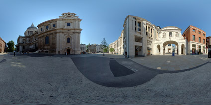
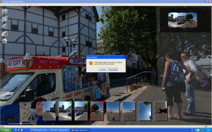
To ensure a fair test, we then ran the same images through PTgui 5.1 which also featues a recently revamped stitching engine at a mere 59 Euros.


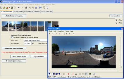
PTgui ran the autostitch first time, resulting in a new perfect panorama merged and saved in 5 minutes. They were no noticeable errors and the interface is clear and easy to use. Behind the scenes PTgui also features a number of advanced options on blending and control points, which can be offputting to the casual user but with such a precise autostitch engine they will probably never need to use them.

Stitcher 5 has been a massive disappointment where as PTgui equals in its surprise in terms of speed and accuracy. We cant even go back to our old version of Stitcher as to install the version 5 demo all previous versions need to be unintstalled first.

RealViz have a lot of ground to make up, PTgui is streets ahead and a tenth of the price. The verdict is ultimately disappointing.

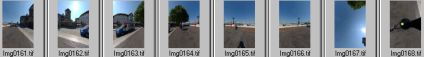
We have made the images available online for any user who wants to run the same tests. You can download the zipped archive here (Saved as jpg to reduce file size 7Mb)

2005-09-27

Leadenhall Market London Panorama


Leadenhall Market is a covered Victorian structure housing a unique range of shops, produce and small boutiques. Designed by Sir Horace Jones in 1881 it has been a site of trading since the 14th Century.

View the Quicktime panorama of Leadenhall Market, London (3.4mb).

As a test we have also put the panorama online in the Devalvr viewer(Devalvr.com) which directly opens QuickTime VR. This is interesting as it means users are no longer are required to download the hefty QT plugin which only comes bundled with iTunes.

View the Devalvr panorama of Leadenhall Market, London (3.4mb).

The panorama view can be resized via the right hand drag icon (a triangle) or viewed full screen via the left hand menu.

Any thoughts or comments on performance are welcome.

City Hall London Panorama


City Hall is home to the Mayor of London, the London Assembly and the GLA, who in July 2002 became tenants of this striking rounded glass building on the south bank of the Thames near Tower Bridge. Members of the public may visit parts of City Hall Monday to Friday from 8am to 8pm and on occasional weekends.

View the Quicktime panorama of the GLA Debating Chamber, London (2.3mb).

2005-09-26

National Mapping Data with Google Earth


The main area of the Virtual London model was developed in both ESRI's ArcGlobe and Kinetix 3D Studio Max - largely by Steve Evans at CASA. We have now been able to export this data direct to Google Earth, allowing a rapid model of London to be visualised via the web with acceptable framerates.


There are issues with placement, most likely due to projection which needs to be addressed, but as a proof of concept it illustrates the ability to port highly detailed data to Google Earth.

2005-09-25

Google Earth St Paul's and Digital Elevation Model


As part of our wider Virtual London work in ESRI's ArcScene and 3DStudio Max we have a detailed model of St Paul's Cathedral, London. However for visualisation in Google Earth low polygon count models are required, requiring the basic rebuild of the main London Landmarks.

Pictured above and below is an optimised St Paul's - a simple enough task but problems have arisen with the Google Digital Elevation model (DEM). St Pauls is located on a natural hill in London but the resolution of the DEM is not enough to compensate for the building size and structure.

By default Google Earth drapes the models to the landscape, resulting in a model which slopes, losing the straight lines and introducing distortion. To get around this it can be placed absolute to the ground, resulting in a 11 metre difference between the front and the rear of the building - as it sits on a hill. This has been compensated for in the model but it throws out the actual building height relative to the skyline.

We have placed the model in Google Earth and a link is provided below to fly around the scene, although the issues of heights needs to be resolved at this present moment.


You can download the kmz file to fly into the model in Google Earth here (84k)

Google Earth Canary Wharf


Modelled along the lines of the 30 St Mary Axe post in this blog are three buildings in Canary Wharf. The map overlay is currently imprecise, perhaps showing an error in the accuracy of Google Maps as the buildings load up in the dock with the Google Map view on.

You can download the kmz file to fly into the model in Google Earth here (50k)

2005-09-24

Google Earth Model and Map Overlay


A rapid model of 30 St Mary Axe in London with Google Maps overlayed in Google Earth. The air photography of London is low resolution at the current moment, thus the need to overlay the streets with imagery from Google Maps. The map placement is approx 5 metres out but it illustrates a good proof of concept. Google Earth is also rendering the edge profile the building, this should be sorted in a few days.

Thanks go to the overlay creator at Google Map Overlays

You can download the kmz file to fly into the model in Google Earth here (56k)

2005-09-23

Google Earth London


A week since the last post - so an update on what we are up to.

It is now possible to import your own buildings into Google Earth - as shown above. We are working on this with regards our various models, one of which is the main University Campus. Originally built in Sketchup (see below) we have been able to import it direct to Google Earth.


Linking in the info we have from our previous post with regards Google Maps, its also possible to embed panoramas into Google Earth.


Direct links to the .kmz files will follow asap...

2005-09-12

Google Map Panoramas - Community Walk


Another test of the Google Map system, this time using Community Walk . Panoramas and info are hotlinked on the map.

It also includes full directions to and from each panorama.


View the Google Map

2005-09-06

Tower Bridge London Panorama


Tower Bridge was completed in 1894, after 8 years in construction. The bridge was built to take pressure of London Bridge as the area to its east grew in population.

Built to compliment the Tower of London's gothic architecture, the bridge's unique design the result of a collaboration between Horace Jones, the then City Architect and John Wolfe Barry.

Tower Bridge's colours of red, white and blue are a recent addition, added in 1977 to celebrate the Queen's Silver Jubilee. Previous to the Jubilee the bridge was painted brown.


View the Quicktime panorama of Tower Bridge, London (1.8mb).

2005-09-05

Southwark Cathedral London Panoramas


South Cathedrals fulls title is The Cathedral Church of St Saviour and St Mary Overie. A church has stood on the site for over 1000 years with the first church founded by Mary Overie in the 7th Century.

The building in its present form dates in part from 1220.

Two panoramas of the church provide internal and external views of the structure.


The panoramas can be viewed in full screen via the QuickTime plugin, allowing you to view the scene in 360x180 degrees at high resolution.

View the panorama of Outside Southwark Cathedral, London (3.2mb).

View the panorama of Inside Southwark Cathedral, London (3.1mb).

Hays Galleria London Panorama


Hays Galleria is tucked along side the river between London and Tower Bridge. A mix of small boutiques, coffee shops, bars and restaurants it is a place to browser and relax as part of a river side walk in London.

The galleria is spanned by a steel and glass roof which covers the original Hay's Wharf - built in the 1850's and a centre point for river trade in London.

David Kemp's sculpture 'Navigators' dominates the centre, a nautical sculpture which captures the wharfs link to the river.

View the Quicktime panorama of Hays Galleria, London (3.2mb).

2005-09-02

Temple Bar and St Pauls Cathedral London Panorama


Temple Bar is the last remaining gate of the old City of London. Built by Christopher Wren in 1672, Temple Bar divided Fleet Street and the City of London from the Strand and Westminster. It is infamous as it used to display the decapitated heads of traitors.

It was dismantled from its original location in 1878 and re-erected ten years later in Herefordshire after being purchased by Lady Meux. In 2004 it was moved back to the City of London and now stands between Paternoster Square and St Pauls Cathedral.

View the Quicktime panorama of Charlotte Street, London (2.9mb).

Charlotte Street London Panorama


Charlotte Street is north of Oxford Street and Soho in a region known as Fitzrovia. The name comes from the Fitzroy Tavern (pictured on the corner in the panorama) which was the location for meetings of a number of writers and artists in the area. This name was coined by a group of writers who met at the Fitzroy Tavern at No.16 Charlotte Street between the wars.

The pub, originally the Fitzroy Coffee House, opened in its present form in 1919. Former customers, who coined the name Fitzrovia include including George Orwell, Dylan Thomas, Augustus John and Jacob Epstein.

View the Quicktime panorama of Charlotte Street, London (3.5mb).

Covent Garden - St Pauls, London Panorama


Covent Garden it characterised by its street entertainers, cafes, markets and small unique shops. Close to Leicester Square, it is one of the major tourist areas of London.

The name Covent Garden is derived from its history as a garden of the convent of the Abbey of St Paul. The St Paul's garden supplied nearby Westminster Abbey with fresh produce.

Dominating the west side of Covent Garden is St Paul's Parish Church, serving the Parish of Covent Garden. The Parish boundaries were changed in 1986 to incorporate the Parishes of Holy Trinity, Kingsway and St John, Drury Lane.

The Church was built as a result of the Earl of Bedford, in 1631 requiring the building of four streets to converege onto a square with a chapel and mansions. The design was carried out by Inigo Jones and the church was completed in 1633.

Nowadays the Church front plays host to street entertainers on the main square, over looked by the Punch and Judy pub it is the perfect location for a coffee or a pint in London.


View the Quicktime panorama of Covent Garden, London (2.9mb).

Covent Garden Market London Panorama


At the centre of Covent Garden is the glass covered Piazza, home to many shops and restaurants. The original site was designed in 1638 by Indigo Jones, with its arcaded walks based on the Piazza D` Arme at Livorno.

The site first became a market place in 1671 and has remained in that role ever since. The market on the current site dates back to 1830, rebuilt by the 6th Duke of Bedford.

The architecture from this period remains intact and provides a splendid backdrop to the wider area of Covent Garden.

View the Quicktime panorama of Covent Garden Market, London (3.5mb).

2005-09-01

Church of St Giles in the Field London Panoramas


The history of the site of St Giles in the Field dates back to 1101 with the foundation of a leper hospital. The chapel of the hospital remained when the leper treatment closed in 1547, it is at this time that the site became known as St Giles in the Fields.

The current church on the site dates back to 1730, designed by the architect Henry Flitcroft. Differing in style to Wren's work in the City of London the church was completed in 1734 and provides a unique contrast to the Centre Point building across the way.

Two panoramas of the church provide internal and external views of the structure.


The panoramas can be viewed in full screen via the QuickTime plugin, allowing you to view the scene in 360x180 degrees at high resolution.

View the panorama of Outside the Church of St Giles in the Field, London (3.2mb).

View the panorama of Inside the Church of St Giles in the Field, London (2.7mb).

British Telecom Tower London Panorama


Construction of the British Telecom Tower started in 1961, designed by Chief Architect, Eric Bedford and Senior Architect in Charge, G.R.Yeats. Opened in 1964 the tower stands the 189m (620ft) to dominate the skyline of north central London.

At the time of opening the tower was the tallest building in the United Kingdom and remained so until the Natwest Tower was completed in 1980. The towers main role is one of communications, relaying radio, satellite, television and telephone signals around the country.


View the Quicktime panorama of The British Telecom Tower, London (2.5mb).