
City 17, the location of Half Life 2, represents one of the most immersive digital city architectures currently available - see our Architecture of City 17 Movie for more info. The designer of City 17, Viktor Antonov, is now involved in the forthcoming release 'The Crossing'. The movie below illustrates the first preview of Antonov's take on the digital city:
In todays digital world architects are the designers of the latest gaming environments. Some may sit in wonder at real world architects and their latest buildings, yet in the real world architects are limited to single landmarks or skysrapers. In the digital domain architects can build cities...The Crossing will be interesting to explore.
2007-03-27
Cities in Games - Ant Attack
 Ant Attack, released on the ZX Spectrum in 1983 by Quicksilva, represents the first digital three dimensional city we can recall exploring. Created by Sandy White, the game centred around the walled city Antescher depicted using a 'softsolid 3d' algorithm which allowed the city to be viewed from a switchable isometric perspective.
Ant Attack predates the innovational Knight Lore, created by Ultimate Play the Game, by over a year making the use of such visualisation techniques noteworthy. Indeed 'Crash' magazine, in a review of Ant Attack, described it as 'containing the most breathtaking 3D graphics yet seen on the Spectrum'.
The prefix of the game was simple - to find and save your boy/girlfriend who was lost in a city patrolled by giant ants. The movie below illustrates the game, firstly we find our girlfriend and then before saving her we take a look around the city:
In the days of the ZX spectrum it wasn't possible to gain an overview of the city but a series of landmark structures often provided a guide to its layout and relative location. Today it is of course possible to view the city in its entirety as the image below demonstrates:

In a future post of the Cities in Games series we will take a look further look into the ZX Spectrum and games such as Knightlore, Fairlight and Gunfright.
You can play the Ant Attack online via a The Spectrum Java Emulator, and to find out more take a look at Sandy Whites page.
2007-03-26
Birmingham City of the Future
In terms of Google searches the words city and future often come up on our list. While such searches often bring up interesting insights into the way digital technology and the city are developing, they can also provide a unique insight into urban areas 'as is'. Take a look at the 'Birmingham City of the Future Video':
Partly true, part spoof, it made us smile but also sit back and realise that it represents what Birmingham, and indeed to a lot of our inner cities, are like...(?)
The film was made by Birmingham medical students for the Comedy Revue 2006, uploaded to YouTube by Matthew Doyle.
Partly true, part spoof, it made us smile but also sit back and realise that it represents what Birmingham, and indeed to a lot of our inner cities, are like...(?)
The film was made by Birmingham medical students for the Comedy Revue 2006, uploaded to YouTube by Matthew Doyle.
Book of the Week - Second Life The Official Guide
 Second Life is a virtual world created by its inhabitants, it is as close to Stephensons view of the Metaverse in the seminal novel Snow Crash as you can currently get.
The Official Guide provides a step by step insight into the world of Second Life making it a recommend read before you actually download the software and experience the environment yourself.
Such environments age quickly and in some ways with this book you are buying a snapshot of the history of Virtual Worlds. In a few years we will look back at such environments with amazement at their simplicity but for now we can enter the Metaverse, design our own Avatars and take part in the digital experience that is Second Life.
You can buy the guide via our Amazon's Associate store, if you do let us know your Second Life user name, via the email link in our side bar, and we'll link up with you in the world to answer any questions you may have...
If you don't have a clue what Second Life or the Metaverse is - then we recommend you read Neal Stephensons Snow Crash and then Second Life the Official Guide.
2007-03-23
Urban Line Rider - Part 3
Another in a series of posts on Line Rider. For those who need a recap, Line Rider is a joyous Flash based application whereby you simply draw a line which creates a path for a man on a sledge to ride on. As such its perfect for urban environments as the movie below by Patrick Jeffers, put onto YouTube by traincrossing9, demonstrates:
If you create your own Urban Line Rider scene let us know.. you can start by going to the Line Rider site, music on the Line Rider movie is by Gorillaz.
If you create your own Urban Line Rider scene let us know.. you can start by going to the Line Rider site, music on the Line Rider movie is by Gorillaz.
Handmade Cartography
 Picked this one up via Londonist's Contribute section - a link to a Flickr pool on Hand made Cartography. With over 65 submissions the pool ranges from the spoof, as pictured right which made us smile, to intricate personally produced maps.
Well worth a look, click the image to the right for a larger view..
Remote Assesment - Digital (Cardboard) Geography
The Year 7 class at Court Fields School, Taunton, and St Ursula’s School in Greenwich have used their respective blogs and an innovative use of Windows Movie Maker to remotely asses their city models, built as a homework assignment.
Noel, the Geography Teacher at Court Field's school notes that 'The interesting dimension to this activity is that I haven’t met Melanie (from St Ursula's), and I don’t know anything about her school or her students, other than they seem very keen on Geography'. The use of Windows Movie Maker and blogs to communicate between the two schools is impressively innovative as it adds in another dimension to the geography. This aside the models built by both schools are interesting on their own accord with their linking of the Central Business Districts and transport etc.
Take a look at Noels Digital Geography blog for more info (you may remember Noel from our Fantasy Architecture project) and Gorgeous Geography from Melanie at St Ursula’s.
Both of their blogs demonstrate the recent rise in the ability to communicate geography digitally using either Windows Movie Maker, as we have seen here, or Google Earth, Google Maps etc. If only such technology, and innovative teachers, had been about when we were at school.
2007-03-22
Frank Lloyd Wright in Google Earth
 Ok so its not as impressive as the Frank Lloyd Wright model in the Half Life 2 Engine (see our Movie) but its still an impressive model, this time in Google Earth.
The Robie house, recently uploaded to the Google 3D Warehouse by Austin Metzger, is considered one of the most important buildings in the history of American architecture. Designed by Frank Lloyd Wright for his client Frederick C. Robie the building inspired an architectual revolution.
You can download the model for viewing either in Google Earth or Google SketchUp. Take a look at the Preservation Trust page on Frank Lloyd Wright for more info.
Understanding GIS and Agent Based Modelling
 Understanding Agent Based Modelling and GIS is easier to say than do. What do you do when you have to decide the suitability of a pedestrian evacuation software application to assess the evacuation process of a building? The answer is to turn to our fellow blog at CASA - that of GIS and Agent Based Modelling.
They have a series of working papers online as well as a number of powerpoint presentations. If you wanted to know everything about Agents but were afraid to ask, GIS and Agent Based Modelling is a good place to start...
BBC London Virtual London Coverage
 BBC London broadcast a piece on Virtual London last night, you can view it up until lunchtime (when its replaced with the latest version) via their website.
If you missed the live version of Radio 4's Law in Action, which again contains a section on Virtual London and mapping data, you can listen again via the Radio 4 page.
2007-03-21
Hidden Faces in the Earth - Google Earth
Ok so its not urban and its not research but when your trying to write a paper sometimes you get distracted and find 'The Secret Images in Google Earth' on YouTube:
.... (?)
.... (?)
Twitter Maps - A Unique View of London
As we mentioned in a our previous posts on the real time visualisation of Twitters - Twitter is intriguing, part social network, part text message, part location aware it almost redefines communication in its purest sense. Limited to 140 characters and based around a simple text box - a text box, asking "What are you doing?" it is difficult to understand at first..
The realtime visualisation of Twitter is an interesting visualisation - but in terms of the city then Twitter Maps lets you get down to street level to view people posting their 'Tweets' (that's Twitter language for messages). The screengrab below is the Twitter Map zoomed into London and there are a surprising number of people Twittering this morning:

Twitters are simply about what people are doing - for example in the image above Redmedicine posted 'Finishing breakfast, mopping up a leaky cappuccino and staring down the barrel of another wonderful day. But the sky is blue!' Simple yet addictive and by linking it to a mapping interface it provides a unique visualisation about what people are doing in the city right now.
Twitter is tipped to be the next important social network on the web, indeed CNN Money state that 'the free service, which combines the instant voyeurism of personal blogs with the brevity of text messages, appears to be catching fire, doubling its user base every month. It had 10,000 users by December and expects to hit 100,000 by April. Users post pithy updates on their lives (in no more than 160 characters) via the website, their IM clients, or their mobile devices. These posts can be sent just to their circle of friends or, if the user allows it, they can be added to Twitter's public time line. (A free desktop widget called Twidget also features the updates.)
You can join our Twitter network and take part in the emerging Twitter phenomoenon. At the moment on our side bar to the right are our current Tweets, once we get a network in place we will be able to display other peoples Tweets, which would be an intriguing insight into the readers of Digital Urban.
We will be posting more applications for Twitter networks over the coming weeks.
2007-03-20
Cities and Complexity - Understanding Cities with Cellular Automata, Agent-Based Models and Fractals
 As urban planning moves from a centralized, top-down approach to a decentralized, bottom-up perspective, our conception of urban systems is changing. In Cities and Complexity, Michael Batty offers a comprehensive view of urban dynamics in the context of complexity theory, presenting models that demonstrate how complexity theory canembrace a myriad of processes and elements that combine into organic wholes. He argues that bottom-up processes -- in which the outcomes are always uncertain -- can combine with new forms of geometry associated with fractal patterns and chaotic dynamics to provide theories that are applicable to highly complex systems such as cities.
 Written by Michael Batty, he begins with models based on cellular automata (CA), simulating urban dynamics through the local actions of automata. He then introduces agent-based models (ABM), in which agents are mobile and move between locations. These models relate to many scales, from the scale of the street to patterns and structure at the scale of the urban region. Finally, Batty develops applications of all these models to specific urban situations, discussing concepts of criticality, threshold, surprise, novelty, and phase transition in the context of spatial developments. Every theory and model presented in the book is developed through examples that range from the simplified and hypothetical to the actual. Deploying extensive visual, mathematical, and textual material, Cities and Complexity will be read both by urban researchers and by complexity theorists with an interest in new kinds of computational models.
As William J. Mitchell states Batty provides a powerful new way of thinking about cities in terms of cells and agents, demonstrating how highly organised spatial patterns can emerge from surprisingly simple simple rules and processes. The reviews of the book have been glowing, for example - "Batty is a master at presenting challenging material in 'gentle though rigorous' ways, judiciously combining text, graphics, and notation, and moving from easy-to-grasp toy problems to real examples." from Helen Couclelis, Professor, Department of Geography, University of California, Santa Barbara.
Professor Michael Batty's Cities and Complexity is our current recommended read at digital urban. You can purchase it, currently at discount, via our associate store at Amazon - let us know if your reading it via the email link on our side bar.
Michael Batty is head of our lab at CASA, you can view more of his work via CASA's main site.
Visual City - The Dreaming Wall
I am writing a book chapter at the moment on the 'Visual City' and got thinking about our previous post on Urban Twitters and how the city could be used to visualise such communication. Turns out that by using a computer controlled UV laser projector and phosphorescent panels on a building wall it can, and indeed has been, done:
The Dreaming Wall, movie pictured above, is a project running in a historical square in Milan, conceived as a info-forum it randomly displays sms messages sent by standing in the square or via the Internet - similar in many ways to Twitter.
Take a look at the Dreaming Wall project which can be seen at the Galleria Contemporaneo, Mestre, Italy until March 31st.
Image Cutter - Panorama Viewer
Neil Creek has used our labs (CASA) Image Cutter software to view a stunning panorama online, as the live example below demonstrates (you can close the preview window by clicking on the bottom right hand arrow, navigate using the standard Google Map interface):
The software is aimed at easy viewing of giga pixel images over the web without the need of a plugin. Using the Google Maps interface it 'cuts' up the image into thousands of sections and then creates a web template which can be modified for own usage or embedded into a blog etc.
Take a look at Neil's site for more panoramas and thanks for the comments on the software so far Neil. If you would like to try it yourself,download version 1.1
2007-03-19
Urban Twitter(s)
 Twitter is intriguing, part social network, part text message, part location aware it almost redefines communication in its purest sense. Limited to 140 characters and based around a simple text box - a text box, asking "What are you doing?" it is difficult to understand at first..
Take a look at Twittervision - Twitters visualised live on a Google Map:

It begins to make sense when you realise you can activate your phone and therefore send messages remotely to a bunch of people.. anyway while we think of the possibilities you can add digitalurban to your twitter network, and then twitter about anything urban with fellow twitters and readers.
Little Big Planet - Cardboard City Rendering
 Involving local communities in making decisions about their local space often involves the creation of a group built model. The model is normally made out of cardboard and creates a 3D environment in which to discuss scenarios and opinions. Known as 'Planning for Real' we have always thought how interesting it would be to create a digital 3D model with a similar look. You only have to look towards the forthcoming Playstation 3 game 'Little Big Planet' in the movie below to see how well cardboard representations of buildings work:
 Last year we ran a Fantasy Architecture project with Court Fields Community School, whereby students sent in drawings of architecture and we reconstructed them in 3D. A good follow up project would be to leave submissions as drawings and import them into a multi-user environment or Google Earth to create a 'cardboard city'.
So if you have a pen a paper handy draw us a building and send it in c/o Andy Hudson-Smith, Centre for Advanced Spatial Analysis, 1-19 Torrington Place, University College London, London, WC1E 7HB, United Kingdom.. or email us via the link in the side bar...
*edit* - The music to Little Big Planet is insanely addictive - */edit*
Test - Dont Order :)

We are pleased to announce the availability of our booklet: Digital Geography - Geographic Visualisation for Urban Environments. Printed in full colour the 10 x 8 inch booklet runs to 64 pages of insights and tutorials on Virtual Earth, Google Earth, Google Maps, Panoramas and Second Life.
With a focus on Neogeography, Web 2.0 and the various emerging techniques for urban visualisation the booklet has been written as a preview to the forthcoming Digital Urban 'recipe book' to be published fourth quarter of 2008.
The booklet is being sold at below cost price on a limited edition basis and is available now.
Priced at £9.99 (worldwide postage and packaging is free) it can be purchased direct via the Buy Now link using PayPal:

Alternatively you can fill out our Order Form (download in .doc or .pdf format) and FAX it direct to our offices at +44 (0)20 7813 2843. Payment is £9.99 per booklet with world wide postage and packing free of charge.
If you have any questions drop us a email or use the usual comment link.
We hope you enjoy the booklet.....
2007-03-18
Perception of Gaming in Architecutre and Transport Modelling - Trainz
Transport based modelling has a firm founding in academia, yet it is the games industry that leads the way in terms of visualisation. It is interesting that although working in the field of visualisation the use of game engines is still viewed as a slightly amusing sideline. An example of this is highlighted by the case that when talking to a colleague in architecture, before my talk at IMAGINA in Monaco entitled 'When Games and Architecture Collide', the person in question could barely conceal their mirth at the topic.
In truth you only get peoples attention when you show the output and the realtime visualisation you can achive with software costing less than £20 ($35). See our posts on Game Engines for examples.
If the use of the word 'Game' gets laughter from people inside the industry, let alone fellow academics, our proposal three years ago to the 'Cross Rail' Board to visualise the Cross Rail route through London using a game known as Trainz suffered a similar fate. The following demo of Trainz highlights its potential:
Trainz is a very accomplished piece of software, not only allowing complex transport simulations but also the ability to import 3D models from other packages. As such we had a functioning demo, with fully texture mapped models and a series of UK rolling stock, operating through parts of the City of London.
It would of been a small jump to visualise the proposed Cross Rail route - sadly the word 'game' meant looks of derision from the members sat around the table in the board room. A 3D visualisation of the Cross Rail route would have been a fantastic leap forward in informing the public on both its benefits and its impacts on the environment, sadly if you look at the Cross Rail website there is no such level of sophistication.
If we had used the term 'Agent based Transport Simulation' we would of probably got the go ahead, its all the same work just a change in wording and a sad indication of the way that games based visualisation is perceived...
2007-03-16
Cities in Games - Tokyo Bus Simulation
 While running a search for 'city simulation' for an up coming conference presentation I came across a movie of the Playstation 2 game 'Tokyo Bus Guide 2'. Not available outside of the Japan, for obvious reasons, the game nevertheless displays an interesting way to view a virtual model of the city.
The majority of real cities in games are based around street car racing and as such it is difficult to appreciate the modelling behind the simulation. In a bus based game the pace is slower so it is easier to view how the city was constructed.
If they were to make a London version they would have to include a 'hoodie' with his/her mobile phone on 'speaker' mode playing 'Urbanz Diss' on the 168 to Camden Town.
2007-03-15
Coverage..
 Radio 4 popped in to talk about the Virtual London model, they talked mainly to the boss 'Professor Mike Batty' - we will be writing about his latest book 'Cities and Complexity' later in the week. The programme 'Law In Action' will be broadcast Tuesday March 20th 16.00GMT. If you hear any beeping noises in the background that's me trying to make the model sound technical, oh the glamour.
If your in Germany you can view Virtual London in more detail, i get to speak this time - Hitec - a technology show via .zdf, see the website for broadcast times and details.
2007-03-14
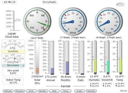
Windows Vista Live Weather Gadget
 One of the new features in Windows Vista is the use of Gadgets, there are a number of weather related gadgets but the majority are mundane and your often left wondering how frequent or reliable the data is.
As such we have used a new Gadget that directly links to our live weather feed and embeds the data in a handy Vista Gadget.
To view our feed simply download the Gadget from here, once its installed search for 'London' via the options screen and pick the second on the list. This will connect you to the live feed from our roof which is updated every 15 seconds.
If you need more frequent updates - every 3 seconds - and want to view the weather full screen you can open our Flash based viewer.
2007-03-13
Recommended Reading and Hardware
 During our PhD and subsequent research we came across several essential books on digital urban environments - as such we have set up an Amazon Associates shop to act as a recommended reading list and guide.
We will be updating it regularly, mainly with books we are reading - think of it as a Digital Urban book club.
There are also several items of hardware, such as the 10.5mm camera lens we use for our panoramas etc. If you buy any camera items and want some tips on panoramas just drop us a email.
View the Digital Urban Guide and Happy Reading..
Open Street Map - Community Led Mapping
 They said it would never work, the project was frowned upon by some in the industry yet its looking like the Open Street Map project is becoming one of the shining lights in the mapping world.
To be honest we should of covered this sooner as one of the guys behind it is Steve Coast (ex of our offices at CASA). The premise is simple - to map as many places and in as much detail as possible using the rise in portable GPS technology. If you get enough people involved, submitting data via their own GPS units, then you can quickly build up local and national coverage. The important point is that all the data is available under a Creative Commons Attribution-ShareAlike 2.0 license, which basically means you can use it freely as long as you acknowlegde the project.
This is where Open Street Map differs from any other mapping project, access to free geographical data is a hot topic at the moment as the article on our Virtual London in the Guardian demonstrates. Now if they could just increase the accuracy of the GPS units and then walk around the perimeter of buildings we would have free building outlines...
If you have a GPS then you can submit your own data to Open Street map.
Sony GPS Review - GeoTag Your Photos in the City?
 On paper Sony's GPS -CS1 is the perfect gadget for the urban photographer/blogger who wants to geotag their photographs for display in either Google Maps or Google Earth.
The attraction of the GPS-CS1 is that it will work with any camera that can record a time and date - ie the majority of digital cameras. The system simply attaches to a bag or belt clip and records your track independently of the camera. Whenever you take a picture the time and date will be the same as the GPS, this allows the supplied software to link the GPS location with the photograph.
By changing the photo's EXIF header to include location the images can then be easily linked to Google Maps or Google Earth via services such as Flickr or Picasa. The unit takes a reading every 15 seconds and battery life lasts 10 hours of continuous use.
On paper then the Sony GPS-CS1 is perfect so why don't we have any examples or Google Maps to demonstrate the output? Basically the unit is close to useless in urban areas - our tests in London only worked if we sat in an open space for a few minutes, as soon as we went to take any photographs the unit lost its signal and stopped tracking.
While GPS coverage in urban areas is a known problem, the Sony unit seems to have a low sensitivity. With only a basic flashing LED to communicate connection it is easy to walk around town tacking photographs only to arrive back at the office to find that you don't have any data.
In short if you live in an urban area then sadly the Sony GPS-CS1 turns out to be an expensive keyring, if your out of town its a great, if expensive, solution to geotagging photographs.
2007-03-12
Realtime London Weather
Our weather station has been offline for a while, ironically it failed due to 'weathering' and the effects of water on its connections. The main components have now been replaced thanks to McMurdo and we now have the system back online.
View the Flash based version, live from our roof, data is updated every 3 seconds.
AI Implant - Crowd Simulation 3D Max
Implementing crowds into 3D can be time consuming - artificial intelligence isn't something you can simply model 'out of the box' as such the AI-Implant plugin for 3D max is well worth a look - take a look at their demo:
AI.implant is an Artificial Intelligence tool and middleware solution that provides professional game developers and training & simulation experts with a solid foundation for building truly realistic and dynamic game environments. Obviously results such as the above movie take time, for a quick start overview the next movie provides a good insight into creating your first agents:
We will have more on AI-Implant and hopefully 'SimTown' running on the Gamebryo engine by Emergent Games Technologies in a forthcoming post.
3D Max - Visualising Agent/Traffic Simulation
Visualisation of complicated agent based simulation - such as traffic or pedestrian modelling often takes second place to the actual simulation process. Yet, if modellers are to communicate to a wider field, the obvious link is to import simulations into 3D modelling software, such as 3D Max. Newlands & Company have refined a series of Max Scripts to allow them to view their simulation data in a 3D environment and the results are impressive:
Newlands and Company provide more details on their site..
Newlands and Company provide more details on their site..
2007-03-11
Canary Wharf Overview Movie
Movies are the obvious choice when you need to depict the urban environment, yet so often the real world is overlooked in favour of the virtual. Only last week we were asked to create a movie of London for a well known organisation using 3D modelling when a standard video capture would of portrayed the scene infinitely better.
The following movie depicts this point, its a simple travelogue by IDJ Media but ends up providing a good overview of the area - something that in 3D would of been a huge project:
Suffice to say that by recommending a 'real world' movie we lost out on any major 3D modelling work and they went out and brought a digital camera...
2007-03-10
Crytek Realtime Architectural Visualisation - 2
In a follow up to our original post on the CryEngine 2 for architectural visualisation we have a movie update:
Of note is the realtime ambient maps demo - we know that criticism of 3D Max is frowned upon in many circles but can you imagine how long such a scene would take to render? To be able to do this in realtime via a game engine is enticing and it makes us wonder why more 3D modelling software, such as 3DMax, don't have better realtime tools built in.
To see more on this and our realtime Oblivion movies take a look at the Game Engine Thread.
2007-03-09
Berlin in Google Earth
A week is a short time in digital urban technologies and where as Denver was by far the best city in Google Earth, it has been out paced by a new release covering Berlin.
We would of covered this sooner but our move to Windows Vista has left us with graphic card problems and thus an inability to capture movies at a high frame rate. As such the post is thanks to the Google Earth blog who have full coverage and the following movie:
Read the full details via Google Earth Blog. Thanks also to Andreas of the Chosaq Blog for sending this in.
Skype + Goolge Earth = Multi-User Google Earth
Unype.com has released an interesting application that links Skype with Google Earth. Linking the two you are able to share Google Earth locations, and therefore collaboratively browse the globe, while talking as per normal via Skype - the linking of Skype and Google Earth is illustrated in the YouTube movie below:
Ok so its not an avatar based multi-user collaborative space in Google Earth but the ability to talk to clients or colleagues remotely, while flying into placemarks, is an attractive proposition.
Visit Unype to download the application..
Ok so its not an avatar based multi-user collaborative space in Google Earth but the ability to talk to clients or colleagues remotely, while flying into placemarks, is an attractive proposition.
Visit Unype to download the application..
Google Map Icons in the Real World
 In the short time since the release of Google Maps the icons to designate place have become all too familiar. Aram Bartholl has taken the icon and placed it into the real world - simple concept art which is almost disturbingly familiar when viewed in context.
The YouTube movie below provides a walk through from the Google Map overview to the construction and finally its mounting in the correct location:
2007-03-08
Playstation 3 Home - Video
After our earlier post on the annoncement of 'Home' for the Playstation 3 we now have a video which explains the concept:
To be honest its impressive and suddenly make's XBox Live look out of date, virtual worlds are about to go mainstream..
To be honest its impressive and suddenly make's XBox Live look out of date, virtual worlds are about to go mainstream..
Google Earth using the Wii Remote
Previous posts have looked at using the Xbox controller to navigate Virtual Earth and our use of ping pong balls and LED's to control Google Earth ala Minority Report - now you can control Google Earth using the Nintendo Wii Remote:
Interesting, the Space Navigator still seems to be the best solution however..
Interesting, the Space Navigator still seems to be the best solution however..
Line Rider Across the Rooftops
Continuing our posts on Line Rider a movie posted by Zoctogon caught our eye featuring Line Rider across the urban rooftops:
If you create your own Urban Line Rider scene let us know.. you can start by going to the Line Rider site.
If you create your own Urban Line Rider scene let us know.. you can start by going to the Line Rider site.
Sony 'Home' Virtual Space on PS3
 Sony has announced plans for a multi-user environment, similar to Second Life, on the Playstation 3. Known as 'Home' the aim is to create a community led world whereby users can build and perhaps more importantly buy virtual objects.
Virtual economies are increasingly attracting the eye's of the big players and its unsurprising that Sony is taking a leap into Virtual Words. Sony's Playstation 3 has attracted some negative press recently due to the high price tag and changes in hardware design for the European launch. The introduction of a virtual world on the PS3 is interesting but you cant help thinking that its not really about the users but more about extracting money from them once they are in the world.
Perhaps its a cynical view and one made due to a lack of coffee so far this morning but we cant get excited about a virtual world on a console, especially from Sony. Maybe that shows just how much bad press Sony has had and how its affecting the views of people towards the £425 PS3.
It'll be interesting to see what level of building tools are provided though...
2007-03-05
Urban Line Rider
Line Rider is a joyous Flash based application whereby you draw a line and click play - at which point a man on a sledge rides the line accordingly to your layout. As such its perfect for urban environments as the movie below by unconed demonstrates:
If you create your own Urban Line Rider scene let us know.. you can start by going to the Line Rider site.
If you create your own Urban Line Rider scene let us know.. you can start by going to the Line Rider site.
Image Cutter Software - 1.1 Update
A update to the Image Cutter software- the update fixes a bug which caused images of certain sizes not to display. A live example of the Image Tile output is pictured below:
Download version 1.1
Download version 1.1
Subscribe to:
Comments (Atom)