CityDashBoard TalesofThings MapTube
Qrator Tutorials About Digital Urban
MRes ASAV SurveyMapper Contact Us

2006-11-29

Favourite Panoramas - Banksy


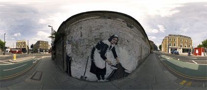
With over 100 panoramas now on the site its easy to lose the images that especially work well and capture the urban scene. As such we are planning to feature some of our favourites as new posts - the first of these is the panorama captured in front of the Chambermaid stencil by the artist Banksy, created in May 2006, on the wall of the Roundhouse in Camden. According to the Camden New Journal Article the maid is a portrait of Leita who worked in a Hotel in Los Angeles.

Libbey Cambell the newly elected Liberal Democrat Councilor stated that "Banksy should of got permission for the art and ask who is going to pay to have it removed?". We are glad to say that is hasn't been removed as the owners of the Roundhouse rather like it and it is refreshing to see innovative images on the streets of London. As for Libbey, you would of thought she would have other things to worry about in Camden to be honest...

View the Quicktime panorama of Banksy's Stencil at the Roundhouse, Camden, London (2.9Mb). You can also simply view a larger version of the image (290K).

If you have any favourites or would like any in 18 x24 inch glossy prints - great Christmas Presents and very exclusive as we dont normally as a rule sell the images - let us know via the email link on the side bar.

Google Earth Panorama Script Back in Place


Gabys script to help create panoramas from Google Earth is now back on the server after getting lost during a ftp transfer - thanks to Gaby for sorting it out.

If your new to this the tutorial allows you to create panoramas from Google Earth using Gaby's script and some photo stitching software. It is possible to output some stunning images using this technique such as the the panoramas sent in so far of: London, New York, Moscow, Belgium, Paris and Syndney.

The most recent addition is from Art Clark (thanks Art!) who has created a panorama of the Desolation Wilderness. The Desolation Wilderness is a 100 square mile federal "wilderness area" directly to the west of Lake Tahoe in California, United States. You can view the panorama from here.

Let us know if you create a panorama using the tutorial as would love to feature it on the blog..

2006-11-27

Modelling Cities - Update

Our model of London extends out to the M25, covering approximately 2000km. Created from LiDAR and Ordnance Survey Mastermap outlines it provides a basic concept of the cities urban morphology. To gain a sense of location and place however you need the local streetscape, from the correct location of the lamppost's and signage to the development of detailed building facades.

Movie Stage 1 Output


Movie Stage 2 Output


The two movies above illustrate work to date with the project mid-way to completion on modelling the streetscape of Newham in London. The second movie includes air photography on both the ground and the buildings, enhancing the level of realism. The next step is the trees, lamppost's, signage and the remaining buildings and then finally porting the model into the Oblivion Engine.

Further updates will follow, we should then have a blueprint on how to rapidly model the local streetscape with the aim of rapid architectural visualisation.

2006-11-23

Sense of Place in Digital Models


At the moment our team at CASA are working on a digital model of Stratford, the main location of the London Olympics 2012. Developed from a 1 metre digital terrain model and 1 metre LiDAR the model is gradually gaining a sense of location and place. This is all important as once a certain level is reached a digital model begins to gain a level of realism.

Central to this has been the addition of air photography, as soon as a photograph is draped on the roads and the roof tops the model moves to the next level. At the moment we are using 25cm imagery with 12cm following shortly thanks to the Ordnance Survey.

The value of good quality aeriel imagery should not be under estimated in the construction of virtual cities, if you can combine air imagery with street level detail and facades you are half way to a decent model.

A movie of progress to date will follow soon, note all images are work in progress.

2006-11-20

Alexandra Palace High Dynamic Range Panorama


First opened as “The People’s Palace” in 1873, Alexandra Palace provided the Victorians with a great environment and recreation centre. Just sixteen days after it’s opening, the Palace, which had already attracted over 120,000 visitors, was destroyed by a fire in the dome.

On 1st May 1875, less than 2 years after the destruction of the original building, a new Palace opened. Covering 7 acres, it was centred on the Great Hall, home to the mighty Willis Organ which was driven by two steam engines and vast bellows.

After certain financial difficulties, an Act of Parliament in 1900 created the Alexandra Palace and Park Trust. The Act required the Trustees to maintain the Palace and Park and make them "available for the free use and recreation of the public forever".

In 1935, the BBC leased the eastern part of the building from which the first public television transmissions were made in 1936. Alexandra Palace was the main transmitting centre for the BBC until 1956, when it was used exclusively for news broadcasts.

You can view the panorama in QuickTime VR (4.1Mb).

2006-11-15

The Getaway PS2/PS3 - London - Cities in Games

We are updating this post with a new movie illustrating the original Getaway model of London. The movie, embedded further down the post, provides a walk through of various London locations. Of note is the basic modelling to cut down polygon counts and the low resolution textures due to hardware limitations. Despite this the model still stands head and shoulders above almost any architects model of the city today.

*****

London has been featured in many games over the years and in increasing levels of detail as game consoles and budgets increase. In the first of a more detailed look into the production of 3D cities for games we turn our eye to the forthcoming PlayStation 3 and The Getaway.

The Getaway originally appeared on the PlayStation 2 recreating a 3D rendition of London covering approximately 10 square miles (16 square kilometers ). The team produced a wire frame model based on a photographic survey of London and then projected the resulting textures onto the geometry. The game is viewed from the street level allowing some simplification of buildings. In a write up for the BBC Senior producer Peter Edward mentions that "The street sites are like a western movie. They don't have wooden slates at the back but they are just the fronts". This is the easiest (if easy is the word) way to rapidly create geometry by ignoring the overall building footprint and pasting on rectified images to create facades.


The recreation of London is impressive and gives an insight into the budget required to build realistic representations of cities in console games. The next Getaway update is scheduled for release to co-inside with the launch of Sony's PlayStation 3 in November 2006. The movie below shows the model development to date, concentrating on the area around Piccadilly Circus:


The use of High Dynamic Lighting, real time traffic, pedestrian simulations, and detailed geometry is impressive. The game looks like it will represent the state of the art in city modelling.

2006-11-14

Buy a Piece of Digital Urban - Print Shop

As a result of various requests we have started making some of our exclusive print panoramas available for purchase - and just in time for the holiday season!

First off is a unique of 35 x 20 inch panoramaic print of Trafalgar Square, London. This is being offered for a limited amount of time so if your interested grab it quick, an exclusive from Digital Urban.

Offered at $22.99 in association with Cafe Press you can order it now.

Click here to take a look around the scene before you purchase in Quick Time Virtual Reality.

Microsoft Photosynth Tech Preview

Microsoft Labs have released a technology preview of their Photosynth application. As we mentioned in our previous post on the subject Photosynth takes a large collection of photos of a place or an object, analyzes them for similarities, and then displays the photos in a reconstructed three-dimensional space.

Developed as a collaboration between Microsoft and the University of Washington the three dimensional space aspect is the key to Photosynth and its inevitable integration with Microsoft's already impressive 3D Earth.


The movie above illustrates us utilising the the technology preview of St Marks Square Venice, of note is the point cloud when you fly around the scene. The full release seems full of potential to not only change the way we view photographs of the cityscape but also navigation. If these photographs can be tagged with additional information it could present a intuitive system for urban management and visualisation - all from simple photographs.

2006-11-08

Microsoft Virtual Earth 3D


We all knew it was coming, David Maguire of ESRI's forthcoming own Virtual Earth - ArcExplorer - mentioned some time back that Microsoft were 'hoovering up data', but now its out in Beta Release, Microsoft's Virtual Earth 3D is impressive. Running directly in the browser (IE, XPSP2 only) Microsoft currently feature 15 cities in 3D, but not the Google Earth type 3D, fully texture mapped 3D direct from the server.

Where as Google Earth's 3D Warehouse allows similar detail, you have to download individual buildings and slow down is notable when over 5 or so landmarks are selected. Microsoft's Virtual Earth however streams in the data in such a way that performance is impressive considering the amount of textures on display.

It is too early to do a Google vs Microsoft comparison, but for shear eye candy Virtual Earth is ahead of the game, albeit to a limited number of users. How did they make all of these models? Its basically all down to money. City building is still time consuming but if you have enough corporate backing they can be built and visualised. Below we feature a flythough of Boston for all those Firefox or Mac users out there that are unable to use Virtual Earth:


The question now is what happens to all the other visualisation companies building cities out there? Sure there will still be a market for high end visualisation but the bar just got raised, combine this with the forthcoming Microsoft Photosynth and a number of people (including myself) must be getting twitchy and looking at their CV's.

Time for a new job? Do you want fries with that?


As a side note, they have not featured London yet, and we have a model ready to roll if anyones interested, they do however feature the London Eye which is back to front. Its good to know that even the big players need a little help sometimes..

Thanks goes to Frank from the Google Earth Blog for the heads up regards the beta release, we were too wrapped up modelling a church in Newham, London, to notice. A movie of which will be online soon...

2006-11-03

Digital Urban in Edge

Being published in Academic Journals/Books etc is all very nice but we were genuinely overjoyed this week while reading EDGE on the tube to find a small write up of our Oblivion game engine work in their 'Out There' section.

You can buy issue 169 in all good newsagents, its in a card wrapper featuring Nintendos up and coming console Wii.

At the moment the lack of posts is due to on going work with Newham council. With limited data its an interesting project to build accurate models direct from ground based imagery which are not suitable for applications such as Photomodeller - images and movies of the church in Stratford High Street will follow shortly and its working a treat in Oblivion.....