CityDashBoard TalesofThings MapTube
Qrator Tutorials About Digital Urban
MRes ASAV SurveyMapper Contact Us

2006-12-20

DigitalUrban Announces Panorama Viewer for Google Earth


digitalurban.blogspot.com is pleased to announce a panorama viewer for Google Earth. Until now to view a panorama you had to use hotlinks to a html browser, now you can view high resolution panoramas directly inside of Google Earth.


The movie above illustrates a series of panoramas using the pre-release version. There are a few issues to iron out with a release aimed for early in January 2007. The viewer will be made available free of charge along with a tutorial detailing how to import any panoramic views at the correct location.

Any thoughts or feedback so far would be welcome.

YouTube does not currently support 16:9 movies, you can download the movie at full resolution and the correct aspect ratio here (39Mb .wmv format)

(note apologies for the poor formatting of the post - blogger seems to currently lose line spacing when you insert a movie).
.

2006-12-16

St John's Church Newham - Google Earth

As part of the Virtual London project at CASA we are modelling part of Newham. Developing the area section by section using a combination of LiDAR/aerial and ground based imagery the latest model to be completed is St John's Church.

St John's was designed by Edward Blore, one of the leading architects of his day, in the Early English style with a tall, ornate south western spire. Interesting architectural features are, externally, the lancets (like stone bridges) and internally the moulded piers (grooves in the pillars) and depressed arches (the tops of the arches are flatter than usual).

Modelling St John's has become a slight labour of love in CASA with the aim to produce a rapid modelling technique giving way to frequent visits and concentration on reproducing the ornate windows and architecture.


The movie above displays the model in Google Earth (music:Requiem, Mozart performed by Le CHOEUR DES MARAIS). In the coming weeks the church will be imported into the Oblivion Engine and merged with the developing model of the area, you can view progress to date here. The raw model (24Mb) will be available for download in kmz format early next week.

Thanks goes to Chris Parker for his work on the model.
.

2006-12-12

Google Earth Data Visualisation Sample

As part of our GeoVue project at CASA we are looking into ways to rapidly visualise data - one way is via our Freely Available Google Map Creator Software and the second is to move into 3D via Google Earth.


The second phase of the software will allow 3D output, we illustrate an example above visualising accessibility data around London transport locations. Its early days but it allows a quick and easy way to visualise data as well as create movie files for presentations..

2006-12-11

100m Above Treasure Cay - Abaco, Bahamas Panorama


John Housser has sent us in a panorama captured in Google Earth of Treasure Cay, Abaco in the Bahamas. Treasure Cay is one of the most popular and elaborate resorts in the Islands, located on the east coast of Great Abaco, it boasts 5.5km (3 1/2 miles) of spectacular sandy beach. You can view John's panorama from his website, its also worth clicking through to the home page to view the other panoramas he has produced - we especially like the 'Overboard the MS Explorer' image.

If your new to this our tutorial allows you to create panoramas from Google Earth using Gaby's script and some photo stitching software. It is possible to output some stunning images using this technique such as the the panoramas sent in so far of: London, New York, Moscow, Belgium, Paris, Sydney and The Desolation Wilderness.

If you create your own panorama from the tutorial let us know and we will post it on the blog..

2006-12-07

Digital Urban in 3D World

Thanks to Joanne at UEL for the heads up on this, the blog is featured in this months 3D World Magazine. Fabio Alviani sent in a letter highlighting the games engines post on the blog and it looks like 3D World will be running a feature shortly on Digital Architecture. Thanks Fabio, the magazine is available in all good newsagents...

2006-12-06

Aerial University College Quad Panorama


The Universities main building, pictured in this panorama, was designed by William Wilkins and constructed between 1827 and 1828. The building is centered on a Corinthian portico which is reminiscent of the British Museum, (constructed a couple of years earlier).

After the building of University College London Wilkins went to design the National Gallery in Trafalgar Square.

View the Quicktime panorama of The University of London Quad, London (2.6mb).

Digital Urban Flickr Group


We have set up a DigitalUrban group on Flickr for readers to share any urban photos or 3D renders relating to the built environment. So far we have 12 images online and welcome the first member - James Bell of the excellent panorama site jamesbells.com

Its easy to join the group, simply login or set up a Flickr account and click here to join the DigitalUrban Group.

There is also the ability to post questions or thoughts in the discussion link. If you have any photographs you would like to share we encourage you to join - we might even set up a monthly prize for best urban image :)

2006-12-05

Urban Images with Flickr/Splashr

We've been slow on the uptake with Flickr but we finally have some photos uploaded as the result of the new tool from Splashr to display images. Thanks go to Digital Geography for the pointer to this.


As can be seen above you can use Splashr to create a simple presentation tool for any set of Flickr images (click the images to have a go). Its easy to use and well worth a try..

You can view the image presentation full screen from here (much better as they are tiny on the blog!).

We hope to get some more images up on Flickr asap - if anyone has any Flickr tips and tricks or groups to join let us know. To view our photographs direct in Flickr, click here.

2006-12-04

CASA Announces Google Map Creator

Google Map Creator is a freeware application designed to make thematic mapping using Google Maps simpler. The software is part of the GeoVUE project at CASA, sponsored by the ESRC as a node in the National Centre for e-Social Science.


Available as a free download the software enables a user to import a .shp files and export the data overlayed on Google Maps. Using Google Map Creator it is a simple three step process to go from raw data to visualization on your own webserver. Differing considerably from other similar .shp convertors, the software is available as freeware and aimed at ease of use.


In the pre-release stage a variety of thematic map for different parts of the world were produced to test the viability of the application with real data on production web servers. A complete set of help documentation is provided as well as a worked example providing a step by step guide to creating your first Google Map from .shp data.

You can download Google Map Creator and view the online documentation from here.

ESRI ArcGIS Explorer Beta - GIS for Everyone (?)

ESRI's ArcGIS Explorer loads with the banner 'GIS for Everyone'. At a first look however the beta product has a long way to go before it allows GIS for the masses.

The main plus point of Explorer is its license free distribution, allowing local government to install it on their desktops, which is not possible with Google Earth unless they pay for the pro version. This alone makes Explorer a inviting prospect for data visualisation and query. Combine this with the possibility to import .shp files and carry out GIS functionality via a ArcServer linkage and its a product that does indeed have the potential to offer GIS for Everyone.

At the moment however it appears to be slow, clunky and lacking features that users of other Digital Globes - such as Google Earth - are used to. As a first test we loaded up our KML file of London, which now extends cover 2000km of the city. Each section of London is divided into KML Network Links allowing each model to seamlessly load in Google Earth. Explorer on the other hand is not able to load the top level KML file, resulting in the the global view zooming into Africa.

We finally found a way around this by opening the files individually but the render times are painfully slow on a machine with 3Gb of ram and a top end graphics card. Where as in Google Earth we can fly around the city with smooth framerates, in Explorer the scene redraws frequently leading to a frustrating load times and a poor data viewing experience.


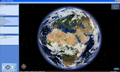
Google Earth excels in the ability of the user to drag a image around the globe and self geo-reference. Explorer, on the other hand, will not allow to the user to load a raster overlay without a spatial reference file. This is exasperating and clearly goes against the aim of GIS for Everyone - if you have to know about spatial co-ordinate systems to load in a simple .jpg or .tif file how can it be GIS for Everyone (?).

At first look ArcGIS Explorer is sadly disappointing with poor rendering of KML files and the ability to add data only if you are GIS literate.

We hope these issues can be sorted out before its full release.

2006-12-01

GigaPixel Panoramas viewed in Google Maps - Genius


We wish we had thought of it ourselves, but the credit goes to Greg Downing and the team at XRez for using Google Maps to display high resolution images. By using a zoom lens and stitching software you can capture in scene in extremely high resolution - typically in excess of 95,000 by 40,000 pixels using a 300mm lens and 612 overlapping images.

If you then take the technology behind Google Maps and replace the maps with the resulting image you get a plugin free navigation tool.

The XRez site is well worth a visit...