
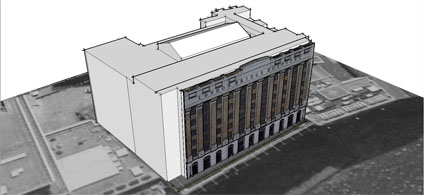
We were about to release a few of our older photomapped models and encountered a problem with placing the models in Google Earth. Using the standard Sketchup technique of grabbing a Google Earth location and then exporting results in a model a good 20 metres out of place.
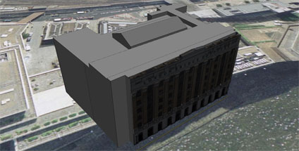
Its all nicely lined up in Sketchup via Google Earth but when the files loaded its shifted. Terrain is on so the only thing we can think of is a slight bug somewhere in the process.
Any thoughts would be welcome.. and while we are here the lighting model in Google Earth looks like it needs a bit of a tweak to make sure the buildings are evenly lit. Its clear from our screengrab that the textures are coming in dark if they are facing north.....
I have run into a similar problem when placing a model I've developed. The issue appeared in the upgrade to v4 (mac). From what I observed, it could be the main sphere model that was being used was modifed fr te upgrade but the code for placing models on it were not. The terrain problems I have run into only occur when vertical exaggeration is anything but 1:1, as the import/expot process seems to be exlusive to this ratio. I have also run into difficulties with height registraiton of buildings.
ReplyDeleteMy suggestion is this, set GE to 1:1 terrain exageration, turn terrain on, snapshot an orthographic view into GE from the lowest elevation possible. Create your model or position your model, then export into GE. Double check how the model is reference to the ground in the shared style button of the layer information, this may give some clues if it doesn't work.
Please let me know, it would be good to have this ironed out.
Thanks for the tip srfn, it turns out that a reboot sorted the problem out. Which i guess still leaves me in the dark as to why it happened...
ReplyDeleteThat is interesting that the reboot helped... I was going to add that I use alot of conversions from lat/long to UTM to get my models in the correct positions in a 3D world and the accuracy is withing about 1-10 meters.
ReplyDeleteI was just searching for a way to place 2263 objects in Google earth when I found this post. I have one object that needs to be placed in several locations. I don't want to place them all by hand and I have the lat/long for each object. any suggestions?