
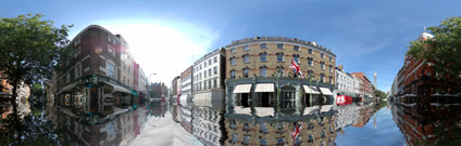
In light of the previous post on flooding London we looked into the ability to visualise flooding levels in a panoramic image. There are various problems involved including making sure the warping of the flood detail in photoshop matches the photograph. Some seams are noticeable but it still gives the illusion of street flooding.
View the Quicktime panorama of Charlotte Street, London, Flooded(1.9mb).
Looks very realistic - can you tell more about the necessary work in Photoshop?
ReplyDeleteIf you run a search for Flood plugin you should come up with software from Flaming Pear. Its powerful and has a 30 day trial.
ReplyDeleteHope that helps,
andy